IMAGES TAKEN NEAR TO
Parrock Lane, HARTFIELD, TN7 4AS
Introduction
This page details the photographs taken nearby to Parrock Lane, TN7 4AS by members of the Geograph project.
The Geograph project started in 2005 with the aim of publishing, organising and preserving representative images for every square kilometre of Great Britain, Ireland and the Isle of Man.

There are currently over 7.5m images from over14,400 individuals and you can help contribute to the project by visiting https://www.geograph.org.uk
Image Map
Images are licensed for reuse under creativecommons.org/licenses/by-sa/2.0
Notes
- Clicking on the map will re-center to the selected point.
- The higher the marker number, the further away the image location is from the centre of the postcode.
Image Listing (14 Images Found)
Images are licensed for reuse under creativecommons.org/licenses/by-sa/2.0
Image
Details
Distance
1
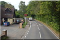
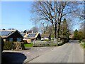
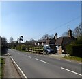
Parrock Lane, Upper Hartfield
Parrock Lane, heading out of the village of Upper Hartfield in East Sussex. The signs indicate that the speed limit changes here to the national speed limit.
Image: © Malc McDonald
Taken: 14 Jul 2018
0.03 miles
2
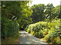
Parrock Lane
Entering the 60mph speed limit on this narrow country lane.
Image: © Oast House Archive
Taken: 25 May 2011
0.04 miles
3
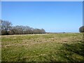
Church Field
The name of the field according to Hartfield's 1842 tithe map bounded by Parrock lane to the south and Hodore Wood to the west.
Image: © Simon Carey
Taken: 26 Mar 2022
0.08 miles
5
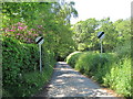
Parrock Lane, Upper Hartfield
The lane heads north from the B2110 then west to provide access to the small hamlets of Upper and Lower Parrock before meeting the B2110 again north of Colemans Hatch.
Image: © Simon Carey
Taken: 26 Mar 2022
0.14 miles
7
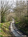
Parrock Lane
There is a substantial holloway on both sides of Hodore Wood, this is the western side.
Image: © Simon Carey
Taken: 26 Mar 2022
0.14 miles
8
Cat Street, Upper Hartfield
The B2110 heading west to Colemans Hatch and Forest Row.
Image: © Simon Carey
Taken: 26 Mar 2022
0.14 miles