IMAGES TAKEN NEAR TO
The Forstal, TUNBRIDGE WELLS, TN3 9JZ
Introduction
This page details the photographs taken nearby to The Forstal, TN3 9JZ by members of the Geograph project.
The Geograph project started in 2005 with the aim of publishing, organising and preserving representative images for every square kilometre of Great Britain, Ireland and the Isle of Man.

There are currently over 7.5m images from over14,400 individuals and you can help contribute to the project by visiting https://www.geograph.org.uk
Image Map
Images are licensed for reuse under creativecommons.org/licenses/by-sa/2.0
Notes
- Clicking on the map will re-center to the selected point.
- The higher the marker number, the further away the image location is from the centre of the postcode.
Image Listing (9 Images Found)
Images are licensed for reuse under creativecommons.org/licenses/by-sa/2.0
Image
Details
Distance
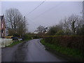
1
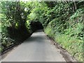
The Forstal looking towards Holly Cottages
Just around the corner is the junction with Groombridge Lane and Eridge Road.
Image: © Marathon
Taken: 11 Sep 2016
0.00 miles
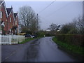
2
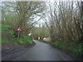
Entrance to Gull Wing Farm
This is marked as Cobbarn Farm on the Ordnance Map. The decorations on the gateposts are a novel touch.
Image: © Marathon
Taken: 11 Sep 2016
0.05 miles
5
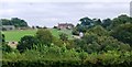
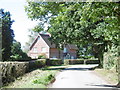
Cobbarn House seen from the Tunbridge Wells Circular Path
Image: © N Chadwick
Taken: 27 Aug 2009
0.07 miles
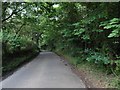
7
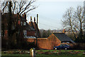
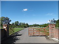
Cobbarn Farm Oast, Eridge Green, East Sussex
Image: © Oast House Archive
Taken: 24 Jan 2009
0.10 miles