IMAGES TAKEN NEAR TO
Tangier Lane, TUNBRIDGE WELLS, TN3 9HD
Introduction
This page details the photographs taken nearby to Tangier Lane, TN3 9HD by members of the Geograph project.
The Geograph project started in 2005 with the aim of publishing, organising and preserving representative images for every square kilometre of Great Britain, Ireland and the Isle of Man.

There are currently over 7.5m images from over14,400 individuals and you can help contribute to the project by visiting https://www.geograph.org.uk
Image Map (Loading...)


Getting Data...Please wait
Leaflet Map data © OpenStreetMap
Images are licensed for reuse under creativecommons.org/licenses/by-sa/2.0
Notes
- Clicking on the map will re-center to the selected point.
- The higher the marker number, the further away the image location is from the centre of the postcode.
Image Listing (9 Images Found)
Images are licensed for reuse under creativecommons.org/licenses/by-sa/2.0
Image
Details
Distance
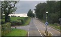
1
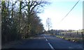
The pavement changes sides on the A267
Presumably to avoid the busy Bunny Lane junction [which is also the site of a 119 metre spot height].
Image: © Christine Johnstone
Taken: 2 Aug 2018
0.17 miles
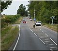
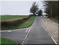
5
'Footway Closed' on the A267
Fortunately for the photographer, it was still passable.
Image: © Christine Johnstone
Taken: 2 Aug 2018
0.21 miles
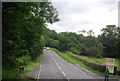
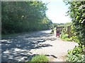
7
View from Bunny Lane
This is near the junction with Eridge Road (A26).
Image: © Marathon
Taken: 18 Apr 2021
0.24 miles