IMAGES TAKEN NEAR TO
St. Augustines Close, BEXHILL-ON-SEA, TN39 3AZ
Introduction
This page details the photographs taken nearby to St. Augustines Close, TN39 3AZ by members of the Geograph project.
The Geograph project started in 2005 with the aim of publishing, organising and preserving representative images for every square kilometre of Great Britain, Ireland and the Isle of Man.

There are currently over 7.5m images from over14,400 individuals and you can help contribute to the project by visiting https://www.geograph.org.uk
Image Map
Images are licensed for reuse under creativecommons.org/licenses/by-sa/2.0
Notes
- Clicking on the map will re-center to the selected point.
- The higher the marker number, the further away the image location is from the centre of the postcode.
Image Listing (111 Images Found)
Images are licensed for reuse under creativecommons.org/licenses/by-sa/2.0
Image
Details
Distance
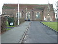
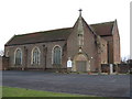
3
St. Augustine's Church, Bexhill
This is taken from the entrance to the Close and shows the green in front of the church.
Image: © Terry Head
Taken: 4 Feb 2010
0.03 miles
4
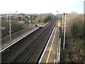
The Railway West of Collington Station, Bexhill
This view is from the footbridge at Collington Station looking westwards in the direction of the Eastbourne and Lewes mainline stations.
Image: © Nigel Stickells
Taken: 30 Dec 2006
0.08 miles
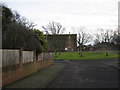
5
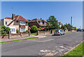
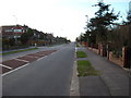
Southcourt Avenue
c.1930s housing in Southcourt Avenue.
Image: © Ian Capper
Taken: 16 Jul 2021
0.11 miles
6
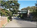
Railway Bridge over the Road
A view of the railway bridge over Westcourt Drive in the Cooden area of Bexhill-on-Sea in East Sussex.
Image: © John P Reeves
Taken: 23 Sep 2021
0.11 miles
7
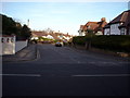
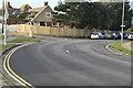
Quiet suburbia, Bexhill-on-Sea
This view of Richmond Grove, taken at its junction with Richmond Avenue, highlights the difference between the town centre, with its crowded pavements and car parking, and the residential outer reaches of Bexhill-on-Sea.
Image: © Bill Johnson
Taken: 22 Jan 2008
0.12 miles
8
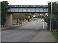
Railway Bridge, Westcourt Drive, Bexhill-on-Sea
The significant feature of this photograph is the white post on the right hand kerb.
The road is prone to flooding at this point and the white post lets those motorists who have stalled in the flood water know exactly how deep it is at that point.
Image: © Bill Johnson
Taken: 24 Jan 2008
0.12 miles
10
Cooden Drive, Bexhill-on-Sea
Pre-war a country lane leading westward to the beach at Cooden.
Residents from this point westward prefer to use a postal address and telephone number which contain the word "Cooden" rather than, in their eyes, the down market "Bexhill-on-Sea"
Image: © Bill Johnson
Taken: 24 Jan 2008
0.12 miles