IMAGES TAKEN NEAR TO
Mount Pleasant, TUNBRIDGE WELLS, TN3 8LU
Introduction
This page details the photographs taken nearby to Mount Pleasant, TN3 8LU by members of the Geograph project.
The Geograph project started in 2005 with the aim of publishing, organising and preserving representative images for every square kilometre of Great Britain, Ireland and the Isle of Man.

There are currently over 7.5m images from over14,400 individuals and you can help contribute to the project by visiting https://www.geograph.org.uk
Image Map (Loading...)


Getting Data...Please wait
Leaflet Map data © OpenStreetMap
Images are licensed for reuse under creativecommons.org/licenses/by-sa/2.0
Notes
- Clicking on the map will re-center to the selected point.
- The higher the marker number, the further away the image location is from the centre of the postcode.
Image Listing (67 Images Found)
Images are licensed for reuse under creativecommons.org/licenses/by-sa/2.0
Image
Details
Distance
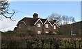
2
House near the junction of Clay Hill Rd and Mount Pleasant
Image: © N Chadwick
Taken: 13 Mar 2010
0.01 miles
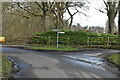
4
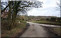
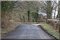
Road junction on Clay Hill Road
Clay Hill Road from Hook Green, bends to the left to climb Clay Hill towards Lamberhurst Quarter. Mount Pleasant leads right towards Lamberhurst. Ellis Wood is in the background.
Image: © David Anstiss
Taken: 3 Jan 2010
0.03 miles
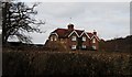
5
Clay Hill Rd and Mount Pleasant junction
Image: © N Chadwick
Taken: 13 Mar 2010
0.03 miles
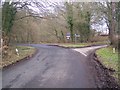
9
Junction of Clay Hill Rd and Mount Pleasant
Image: © N Chadwick
Taken: 13 Mar 2010
0.04 miles
10
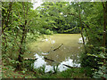
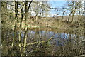
Pond by Clay Hill Road
On the inside of a sharp bend in the road. A rotten tree has been cut down to leave this gap.
Image: © Robin Webster
Taken: 8 Aug 2012
0.04 miles