IMAGES TAKEN NEAR TO
Parsonage Lane, TUNBRIDGE WELLS, TN3 8DR
Introduction
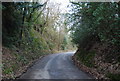
This page details the photographs taken nearby to Parsonage Lane, TN3 8DR by members of the Geograph project.
The Geograph project started in 2005 with the aim of publishing, organising and preserving representative images for every square kilometre of Great Britain, Ireland and the Isle of Man.

There are currently over 7.5m images from over14,400 individuals and you can help contribute to the project by visiting https://www.geograph.org.uk
Image Map
Images are licensed for reuse under creativecommons.org/licenses/by-sa/2.0
Notes
- Clicking on the map will re-center to the selected point.
- The higher the marker number, the further away the image location is from the centre of the postcode.
Image Listing (186 Images Found)
Images are licensed for reuse under creativecommons.org/licenses/by-sa/2.0
Image
Details
Distance
1
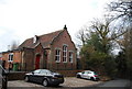
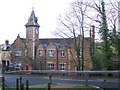
The former Lamberhurst Priory School House
This primary school closed in the 1990s & has been converted into private residences.
Image: © N Chadwick
Taken: 13 Mar 2010
0.02 miles
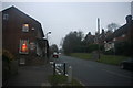
3
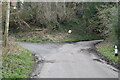
Lane junction, Parsonage Lane
Both lanes lead to the main street in Lamberhurst.
Image: © N Chadwick
Taken: 13 Mar 2010
0.02 miles
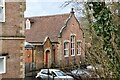
4
The former Lamberhurst Priory School
This primary school closed in the 1990s & has been converted into private residences.
Image: © N Chadwick
Taken: 13 Mar 2010
0.02 miles
5
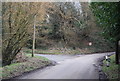
Parsonage Lane
A Quiet lane climbing into Lamberhurst.
Image: © N Chadwick
Taken: 13 Mar 2010
0.03 miles
6
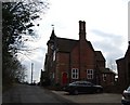
St Mary's Court
This used to be Lamberhurst Old School on Parsonage Lane. Seen from the Broadway. It was built in 1836 in the Jacobean Period. Extended in 1850, when the tower was added and a weathervane was made by a local blacksmith. The tower was later heightened to accommodate the 'Village Clock' dated 1863. It was later used as a school hall, but then sold to developers. Now converted into apartments.
Image: © David Anstiss
Taken: 3 Jan 2010
0.03 miles
8
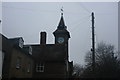
Clock Tower St Mary's Court, School Hill
Formerly Lamberhurst School opened approx. 1833. Now converted to private resodences.
Image: © N Chadwick
Taken: 7 Feb 2010
0.03 miles
10
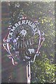
Close-up of Lamberhurst Village Sign
Situated on School Hill, leading into the village. It features the White horse of Kent (Invicta), an Oast House and a lamb. It also has small metal plaque on the post which reads 'Presented by The R.B.L. in memory of C.Suter Esq. of this parish'. See also Image
Image: © David Anstiss
Taken: 27 Sep 2007
0.03 miles