IMAGES TAKEN NEAR TO
Bowsprit Mews, ST. LEONARDS-ON-SEA, TN38 8ER
Introduction
This page details the photographs taken nearby to Bowsprit Mews, TN38 8ER by members of the Geograph project.
The Geograph project started in 2005 with the aim of publishing, organising and preserving representative images for every square kilometre of Great Britain, Ireland and the Isle of Man.

There are currently over 7.5m images from over14,400 individuals and you can help contribute to the project by visiting https://www.geograph.org.uk
Image Map
Images are licensed for reuse under creativecommons.org/licenses/by-sa/2.0
Notes
- Clicking on the map will re-center to the selected point.
- The higher the marker number, the further away the image location is from the centre of the postcode.
Image Listing (20 Images Found)
Images are licensed for reuse under creativecommons.org/licenses/by-sa/2.0
Image
Details
Distance
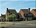
1
Houses in Harbour Way at junction with Mare Bay Close, St Leonards-on-Sea
Image: © Patrick Roper
Taken: 6 May 2022
0.05 miles
2

Houses and gardens in Stonebeach Rise north of Harbour Way
Image: © Patrick Roper
Taken: 6 May 2022
0.05 miles
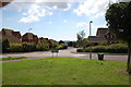
3

Stonebeach Rise at junction with Highwater View, St Leonards on Sea
Image: © Patrick Roper
Taken: 6 May 2022
0.06 miles
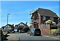
4

Wychnour, Battle Road
Opposite the entrance to Beauport Park Golf Course. Not marked on the 1880s map which suggests very late Victorian or early Edwardian house.
Image: © Simon Carey
Taken: 21 Feb 2007
0.06 miles
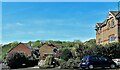
6

Stonebeach Rise, St Leonards, East Sussex
Image: © Oast House Archive
Taken: 19 Dec 2008
0.09 miles
7
Houses and gardens in Coxheath Close, St Leonards-on-Sea
Image: © Patrick Roper
Taken: 6 May 2022
0.09 miles
8
Houses at the junction of Harbour Way and Shingle Court, St Leonards-on-Sea
Image: © Patrick Roper
Taken: 6 May 2022
0.09 miles
9
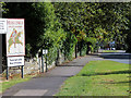
Hastings and St. Leonards sign, A2100 Battle Road
Close up of sign Image
Image: © Oast House Archive
Taken: 29 Sep 2012
0.11 miles
10
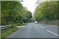
A2100 Battle Road
Towards Battle, with the wall of Beauport Park on the right.
Image: © Robin Webster
Taken: 30 Apr 2019
0.11 miles