IMAGES TAKEN NEAR TO
Main Road, WINCHELSEA, TN36 4BA
Introduction
This page details the photographs taken nearby to Main Road, TN36 4BA by members of the Geograph project.
The Geograph project started in 2005 with the aim of publishing, organising and preserving representative images for every square kilometre of Great Britain, Ireland and the Isle of Man.

There are currently over 7.5m images from over14,400 individuals and you can help contribute to the project by visiting https://www.geograph.org.uk
Image Map (Loading...)


Getting Data...Please wait
Leaflet Map data © OpenStreetMap
Images are licensed for reuse under creativecommons.org/licenses/by-sa/2.0
Notes
- Clicking on the map will re-center to the selected point.
- The higher the marker number, the further away the image location is from the centre of the postcode.
Image Listing (27 Images Found)
Images are licensed for reuse under creativecommons.org/licenses/by-sa/2.0
Image
Details
Distance
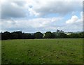
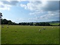
2
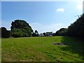
Six Acres
The name of the field according to Icklesham's 1845 tithe map which has been split into two separate sections, this is the smaller of the two located to the south of Toke Farmhouse. Maple Cottage on the left and Tarn House on the right are at the far end of the field.
Image: © Simon Carey
Taken: 1 Aug 2019
0.08 miles
3
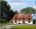
Toke Farm, Icklesham
A 16th century farmhouse now located on the western edge of the village.
Image: © Simon Carey
Taken: 1 Aug 2019
0.12 miles
4
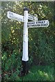
Old Direction Sign - Signpost, A259 Main Road, Icklesham
Black iron cap finial - 3 arms; East Sussex wood by the UC road, in parish of Guestling (Rother District). Verge opposite junction of Broad Street with Main Road.
Surveyed
Milestone Society National ID: SX_TQ8616
Image: © Milestone Society
Taken: Unknown
0.13 miles
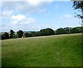
5
Stable Field
The name of the field according to Icklesham's 1845 tithe map located to the north west of Toke Farmhouse.
Image: © Simon Carey
Taken: 1 Aug 2019
0.14 miles
6
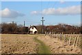
Footpath to Main Road
Footpath from Watermill Lane.
Image: © Oast House Archive
Taken: 8 Mar 2012
0.14 miles
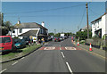
7

Broad Street, junction with A259, Icklesham
Image: © Stacey Harris
Taken: 30 Jun 2012
0.15 miles
8
Four Acres
The name of the field according to Icklesham's 1845 tithe map located to the east of the public footpath.
Image: © Simon Carey
Taken: 1 Aug 2019
0.16 miles
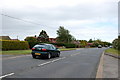
9
A259 passes The Robin Hood
When I write "passes" I could have substituted stops outside, because a large car boot sale in a field up the road was causing the evident tailback.
Image: © Stuart Logan
Taken: 27 May 2012
0.17 miles
10
Malthouse Field/Marlpit Field
The name of the fields according to Icklesham's 1845 tithe map that have been merged along with Image to the north to form a single unit. Malthouse Field was in the foreground adjacent to the public footpath whilst Marlpit Field was to the south and west.
Image: © Simon Carey
Taken: 1 Aug 2019
0.18 miles