IMAGES TAKEN NEAR TO
Castle Farm Lane, TN36 4AZ
Introduction
This page details the photographs taken nearby to Castle Farm Lane, TN36 4AZ by members of the Geograph project.
The Geograph project started in 2005 with the aim of publishing, organising and preserving representative images for every square kilometre of Great Britain, Ireland and the Isle of Man.

There are currently over 7.5m images from over14,400 individuals and you can help contribute to the project by visiting https://www.geograph.org.uk
Image Map
Images are licensed for reuse under creativecommons.org/licenses/by-sa/2.0
Notes
- Clicking on the map will re-center to the selected point.
- The higher the marker number, the further away the image location is from the centre of the postcode.
Image Listing (51 Images Found)
Images are licensed for reuse under creativecommons.org/licenses/by-sa/2.0
Image
Details
Distance
1
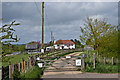
River Brede Farm
Farmhouse alongside River Brede.
Image: © Ian Capper
Taken: 11 May 2013
0.01 miles


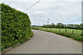
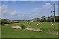
5
Part of Castle Farm
The Saxon Shore Way goes around the back of Castle Farm on the way to Camber Castle and Rye.
A lot going on with the clouds today, but the sun keeps on shining.
Image: © Des Blenkinsopp
Taken: 17 Aug 2020
0.08 miles


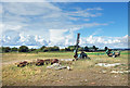
8
Castle Farm Cottages, Winchelsea Beach
A pair of cottages near to Castle Farm that were built after the Second World War.
Image: © Simon Carey
Taken: 21 Apr 2019
0.09 miles

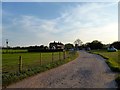
10
Castle Farm
Farm on the levels between Winchelsea and Rye, close to Camber Castle.
Image: © Ian Capper
Taken: 11 May 2013
0.10 miles