IMAGES TAKEN NEAR TO
Cottage Lane, HASTINGS, TN35 4RT
Introduction
This page details the photographs taken nearby to Cottage Lane, TN35 4RT by members of the Geograph project.
The Geograph project started in 2005 with the aim of publishing, organising and preserving representative images for every square kilometre of Great Britain, Ireland and the Isle of Man.

There are currently over 7.5m images from over14,400 individuals and you can help contribute to the project by visiting https://www.geograph.org.uk
Image Map
Images are licensed for reuse under creativecommons.org/licenses/by-sa/2.0
Notes
- Clicking on the map will re-center to the selected point.
- The higher the marker number, the further away the image location is from the centre of the postcode.
Image Listing (14 Images Found)
Images are licensed for reuse under creativecommons.org/licenses/by-sa/2.0
Image
Details
Distance
1
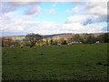
Wealden Landscape from Westbrook Lane
The white house to the right is Hillside, the far view is the rising northern portion of the Brede river valley.
Image: © Simon Carey
Taken: 21 Feb 2007
0.13 miles
3
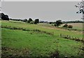
Forge Stream valley looking west from Rocks Hill, Westfield
Image: © Patrick Roper
Taken: 13 Aug 2018
0.17 miles
4

Grey poplar at Miller's Hill
This is a female grey poplar (Populus x canescens) growing by the layby where Miller's Hill joins Rocks Hill. Female grey poplars are very much rarer than males and the identity of this one was confirmed by R.D.Meikle, an expert on poplars and willows.
Image: © Patrick Roper
Taken: 4 May 2017
0.18 miles
5

Trunk of grey poplar
This is the trunk of a female grey poplar (Populus x canescens) growing by the layby where Miller's Hill joins Rocks Hill. Female grey poplars are very much rarer than males and the identity of this one was confirmed by R.D.Meikle, an expert on poplars and willows.
Image: © Patrick Roper
Taken: 4 May 2017
0.18 miles
6
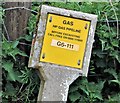
High pressure gas pipeline marker, Rocks Hill
A sign where the pipeline goes under the road.
Image: © Patrick Roper
Taken: 4 May 2017
0.19 miles
8
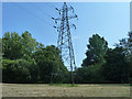
Pylon on Hartley - Hastings 132 kV route PNB
This ought to be pylon PNB80 on the UK Power Networks route, but it lacks an identification plate.
Image: © Robin Webster
Taken: 7 Aug 2014
0.20 miles
9
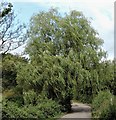
Weeping willow beside Rocks Lane, Westfield
Image: © Patrick Roper
Taken: 13 Aug 2018
0.20 miles
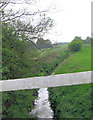
10

Bridge over Forge Stream at Rocks Hill, Westfield
Image: © Patrick Roper
Taken: 13 Aug 2018
0.21 miles