IMAGES TAKEN NEAR TO
Waites Lane, HASTINGS, TN35 4AR
Introduction
This page details the photographs taken nearby to Waites Lane, TN35 4AR by members of the Geograph project.
The Geograph project started in 2005 with the aim of publishing, organising and preserving representative images for every square kilometre of Great Britain, Ireland and the Isle of Man.

There are currently over 7.5m images from over14,400 individuals and you can help contribute to the project by visiting https://www.geograph.org.uk
Image Map
Images are licensed for reuse under creativecommons.org/licenses/by-sa/2.0
Notes
- Clicking on the map will re-center to the selected point.
- The higher the marker number, the further away the image location is from the centre of the postcode.
Image Listing (31 Images Found)
Images are licensed for reuse under creativecommons.org/licenses/by-sa/2.0
Image
Details
Distance
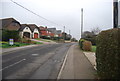
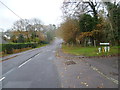
2
Waites Lane, Fairlight
After leaving Pett Level along Pett Level Road, the road steadily rises and it appears that Waites Lane is the first opportunity to return to the coastline at the top of Fairlight Cliffs. It isn't and just leads to the sprawling development of Fairlight. A sign on Pett Level Road, just before it becomes Battery Hill, makes this clear but it is easily missed - see http://www.geograph.org.uk/photo/4270667
Image: © Marathon
Taken: 7 Dec 2014
0.02 miles
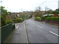
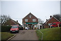
4
The corner of Farley Way and Waites Lane, Fairlight
After leaving Pett Level along Pett Level Road, the road steadily rises and it appears that Waites Lane is the first opportunity to return to the coastline at the top of Fairlight Cliffs. It isn't and just leads to the sprawling development of Fairlight. A sign on Pett Level Road, just before it becomes Battery Hill, makes this clear but it is easily missed - see http://www.geograph.org.uk/photo/4270667
Image: © Marathon
Taken: 7 Dec 2014
0.05 miles
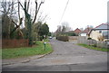
5
Waites Lane, Fairlight
After leaving Pett Level along Pett Level Road, the road steadily rises and it appears that Waites Lane is the first opportunity to return to the coastline at the top of Fairlight Cliffs. It isn't and just leads to the sprawling development of Fairlight. A sign on Pett Level Road, just before it becomes Battery Hill, makes this clear but it is easily missed - see http://www.geograph.org.uk/photo/4270667
Image: © Marathon
Taken: 7 Dec 2014
0.06 miles
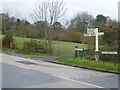
8
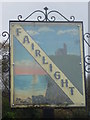
The village sign at Fairlight
The village sign for Fairlight is at the foot of Battery Hill. Not surprisingly, the famous Fairlight Cliffs, as well as the church, feature. Its context can be seen at http://www.geograph.org.uk/photo/4273536
Image: © Marathon
Taken: 7 Dec 2014
0.09 miles
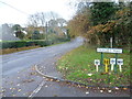
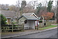
9
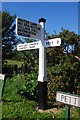
Old Direction Sign - Signpost by Battery Hill, Fairlight parish
Black iron cap finial - 3 arms; East Sussex wood by the UC road, in parish of Fairlight (Rother District), on verge opposite junction of Battery Hill and Pett Level Road with Waites Lane.
Surveyed
Milestone Society National ID: SX_TQ8712B
Image: © Milestone Society
Taken: Unknown
0.09 miles
10
Signpost at Fairlight
After leaving Pett Level along Pett Level Road, the road steadily rises and it appears that Waites Lane is the first opportunity to return to the coastline at the top of Fairlight Cliffs. It isn't and just leads to the sprawling development of Fairlight. This sign on Pett Level Road, just before it becomes Battery Hill, makes this clear but it is easily missed.
Image: © Marathon
Taken: 7 Dec 2014
0.09 miles