IMAGES TAKEN NEAR TO
The Close, HASTINGS, TN35 4AQ
Introduction
This page details the photographs taken nearby to The Close, TN35 4AQ by members of the Geograph project.
The Geograph project started in 2005 with the aim of publishing, organising and preserving representative images for every square kilometre of Great Britain, Ireland and the Isle of Man.

There are currently over 7.5m images from over14,400 individuals and you can help contribute to the project by visiting https://www.geograph.org.uk
Image Map
Images are licensed for reuse under creativecommons.org/licenses/by-sa/2.0
Notes
- Clicking on the map will re-center to the selected point.
- The higher the marker number, the further away the image location is from the centre of the postcode.
Image Listing (110 Images Found)
Images are licensed for reuse under creativecommons.org/licenses/by-sa/2.0
Image
Details
Distance
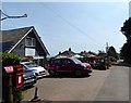
2

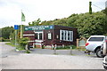
Coastguards Tearooms, Coastguard Lane, Fairlight
Image: © PAUL FARMER
Taken: 9 Jul 2012
0.07 miles
4
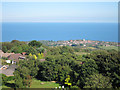
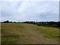
Memorial to Grey Owl at Hastings Country Park
Hastings Country Park Nature Reserve consists of 853 acres of ancient woodland, heathland, grassland and farmland together with three miles of sandstone cliffs and coastline. This memorial plaque to Archibald Stansfel Belaney (aka Grey Owl) is near the Information Centre.
Grey Owl turns out to have been rather a controversial figure. See http://www.bbc.co.uk/news/uk-england-sussex-24127514
Image: © Marathon
Taken: 13 May 2018
0.08 miles
5
Coastguard Tearooms, Coastguard Lane, Fairlight
Popular stop off point for those visiting Hastings Country Park.
Image: © Simon Carey
Taken: 1 Aug 2019
0.09 miles
6
Visitor Centre, Fairlight Country Park
Image: © Julian P Guffogg
Taken: 17 May 2009
0.09 miles
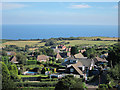

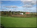
9
Old Kiln Laine
The name of the field according to Fairlight's 1839 tithe map that is now part of Hastings Country Park. The village of Fairlight can be seen in the distance.
Image: © Simon Carey
Taken: 4 Aug 2019
0.10 miles
10
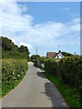
Hill Road, Fairlight
Private road off Coastguard Lane built in the 1930s.
Image: © Simon Carey
Taken: 1 Aug 2019
0.11 miles