IMAGES TAKEN NEAR TO
Southdown Avenue, HASTINGS, TN34 3QE
Introduction
This page details the photographs taken nearby to Southdown Avenue, TN34 3QE by members of the Geograph project.
The Geograph project started in 2005 with the aim of publishing, organising and preserving representative images for every square kilometre of Great Britain, Ireland and the Isle of Man.

There are currently over 7.5m images from over14,400 individuals and you can help contribute to the project by visiting https://www.geograph.org.uk
Image Map
Images are licensed for reuse under creativecommons.org/licenses/by-sa/2.0
Notes
- Clicking on the map will re-center to the selected point.
- The higher the marker number, the further away the image location is from the centre of the postcode.
Image Listing (52 Images Found)
Images are licensed for reuse under creativecommons.org/licenses/by-sa/2.0
Image
Details
Distance
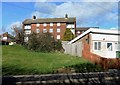
1
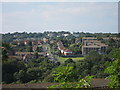
Southdown Road, Broomgrove
Southdown Road in winter seen from Chiltern Drive.
Image: © Patrick Roper
Taken: 7 Dec 2015
0.02 miles
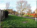
2
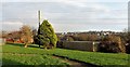
Houses and open area north of Chiltern Drive, Broomgrove
There is a likelihood that the open area will be developed for housing in the near future.
Image: © Patrick Roper
Taken: 11 Feb 2019
0.04 miles
3
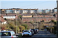
Upper Broomgrove Road
Looking towards apartment blocks at Hurrell Road, Farley Bank and Priory Road.
Image: © Oast House Archive
Taken: 5 Apr 2015
0.04 miles
4
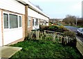
Garden fences, Chiltern Drive, Broomgrove
These fences are in the rear gardens and yards of the small row of terraced bungalows alongside Chiltern Drive.
Image: © Patrick Roper
Taken: 17 Dec 2015
0.05 miles
5
Upper Broomsgrove Road
Seen from Priory Road.
Image: © Oast House Archive
Taken: 30 Jul 2011
0.05 miles
6
Bungalows in Chiltern Drive, Broomgrove
Each of these bungalows in a small terrace beside Chiltern Drive has a postage stamp front garden
Image: © Patrick Roper
Taken: 17 Dec 2015
0.06 miles
7
Terraced bungalows by Chiltern Drive, Broomgrove
Small bungalows in a detached block with transmission lines overhead.
Image: © Patrick Roper
Taken: 7 Dec 2015
0.06 miles
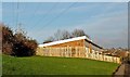
8
Open area at Broomgrove
This small area of amenity grass, trees and shrubs runs on the north side of Chiltern Drive to Southdown Avenue. The houses in the distance are at Ore.
Image: © Patrick Roper
Taken: 7 Dec 2015
0.07 miles
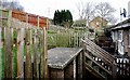
9
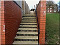
Steps to rear gardens from Chiltern Drive, Broomgrove
Part of a new (2017) housing development on the corner of Chiltern Drive and Upper Broomgrove Road.
Image: © Patrick Roper
Taken: 11 Feb 2019
0.07 miles
10
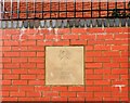
Developer's plaque on wall in Chiltern Drive, Broomgrove
The plaque reads "The Park Lane Group 2017"
Image: © Patrick Roper
Taken: 11 Feb 2019
0.08 miles