IMAGES TAKEN NEAR TO
The Ridge, HASTINGS, TN34 2RJ
Introduction
This page details the photographs taken nearby to The Ridge, TN34 2RJ by members of the Geograph project.
The Geograph project started in 2005 with the aim of publishing, organising and preserving representative images for every square kilometre of Great Britain, Ireland and the Isle of Man.

There are currently over 7.5m images from over14,400 individuals and you can help contribute to the project by visiting https://www.geograph.org.uk
Image Map
Images are licensed for reuse under creativecommons.org/licenses/by-sa/2.0
Notes
- Clicking on the map will re-center to the selected point.
- The higher the marker number, the further away the image location is from the centre of the postcode.
Image Listing (20 Images Found)
Images are licensed for reuse under creativecommons.org/licenses/by-sa/2.0
Image
Details
Distance
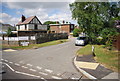
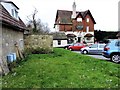
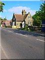
2
Houses at junction of Netherwood Close and The Ridge, Hastings
Image: © Patrick Roper
Taken: 24 May 2022
0.08 miles
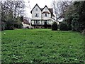
3
House and car park on The Ridge
The house is at the corner of The Ridge and Netherwood Drive and the car park is that of the Robert De Mortain pub once, apparently, the lodge for long demolished Netherwood House.
Image: © Patrick Roper
Taken: 29 Mar 2017
0.10 miles
4
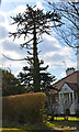
Monkey Puzzle Tree, Park Wood Road, St Leonards
The lower trunk is Ivy-Covered.
Image: © Julian P Guffogg
Taken: 6 Apr 2013
0.11 miles
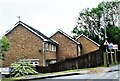
5
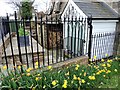
West Cottage, 371 The Ridge, Hastings
A cottage immediately to the east of the Robert De Mortain pub.
Image: © Patrick Roper
Taken: 29 Mar 2017
0.12 miles
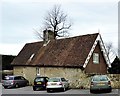
6
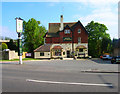
Robert de Mortain Public House, The Ridge
Robert was a half brother of William the Conqueror who reputedly built Hastings Castle. The pub is next to a building called the coach house which may suggest an older coaching inn being on The Ridge (B2093) which was the main dry route out of Hastings.
Image: © Simon Carey
Taken: 5 May 2007
0.12 miles
7
The Robert De Mortain pub and garden from the rear
On the south side of The Ridge (B2093), Hastings
Image: © Patrick Roper
Taken: 29 Mar 2017
0.12 miles
8
The Robert De Mortain pub on The Ridge
The building was originally a lodge house and, before it became a public house in 1946, it was the Ripon Lodge Hotel. In 1878 the building was known as Ripon Lodge. Robert, Count of Mortain was a half-brother of William the Conqueror.
Image: © Patrick Roper
Taken: 29 Mar 2017
0.12 miles
9
Double Lodge, The Ridge
Located in the 'V' on St Helens Park Road an unmade road that accesses St Helen's Wood.
Image: © Simon Carey
Taken: 5 May 2007
0.15 miles
10
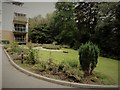
Garden and flats at Quarrywood, Grange Road
A recent development (about five years old) in the grounds of an older house here.
Image: © Patrick Roper
Taken: 4 Sep 2015
0.16 miles