IMAGES TAKEN NEAR TO
Standard Hill, BATTLE, TN33 9NJ
Introduction
This page details the photographs taken nearby to Standard Hill, TN33 9NJ by members of the Geograph project.
The Geograph project started in 2005 with the aim of publishing, organising and preserving representative images for every square kilometre of Great Britain, Ireland and the Isle of Man.

There are currently over 7.5m images from over14,400 individuals and you can help contribute to the project by visiting https://www.geograph.org.uk
Image Map
Images are licensed for reuse under creativecommons.org/licenses/by-sa/2.0
Notes
- Clicking on the map will re-center to the selected point.
- The higher the marker number, the further away the image location is from the centre of the postcode.
Image Listing (10 Images Found)
Images are licensed for reuse under creativecommons.org/licenses/by-sa/2.0
Image
Details
Distance
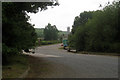
1

The Clangers at Luxford House
Celebrating the accession of Charles III. The display is next to an outhouse on the public footpath.
Image: © Simon Carey
Taken: 3 Sep 2023
0.01 miles
2
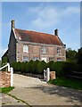
Luxford House
The date over the doorway reads 1702. Originally the farmhouse for Lower Standard Hill Farm.
Image: © Simon Carey
Taken: 3 Sep 2023
0.03 miles
3
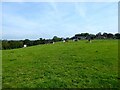
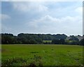
Gate Field/Upper Barn Field
The name of the fields according to Ninfield's 1844 tithe map that have been merged. Upper barn Field is on the plateau bounded by Lower Standard Hill Farm to the east whilst gate Field is on the slope.
Image: © Simon Carey
Taken: 3 Sep 2023
0.06 miles
4
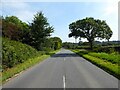
Standard Hill
The A269 heading east to Ninfield.
Image: © Simon Carey
Taken: 3 Sep 2023
0.09 miles
5
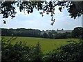
Hop Garden Four Acres
The name of the field according to Ninfield's 1844 tithe map located to the south of the A269.
Image: © Simon Carey
Taken: 3 Sep 2023
0.09 miles
6
Hollow Field
The name of the field according to Ninfield's 1844 tithe map located on the southern side of the A269.
Image: © Simon Carey
Taken: 3 Sep 2023
0.12 miles
7
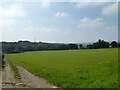
Six Acres/Rushfords
The name of the fields according to Ninfield's 1844 tithe map that have been merged. Six Acres is on the left adjacent to the track whilst Rushfords was to the right bounded to the south by Rough Wood.
Image: © Simon Carey
Taken: 3 Sep 2023
0.13 miles
8
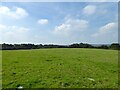
Lower Barn Field
The name of the field according to Ninfield's 1844 tithe map located to the north of the A267.
Image: © Simon Carey
Taken: 3 Sep 2023
0.22 miles