IMAGES TAKEN NEAR TO
Hooe, BATTLE, TN33 9HH
Introduction
This page details the photographs taken nearby to TN33 9HH by members of the Geograph project.
The Geograph project started in 2005 with the aim of publishing, organising and preserving representative images for every square kilometre of Great Britain, Ireland and the Isle of Man.

There are currently over 7.5m images from over14,400 individuals and you can help contribute to the project by visiting https://www.geograph.org.uk
Image Map
Images are licensed for reuse under creativecommons.org/licenses/by-sa/2.0
Notes
- Clicking on the map will re-center to the selected point.
- The higher the marker number, the further away the image location is from the centre of the postcode.
Image Listing (32 Images Found)
Images are licensed for reuse under creativecommons.org/licenses/by-sa/2.0
Image
Details
Distance
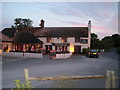
2
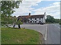
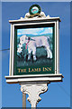
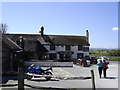
The Lamb Inn
Located on the edge of Pevensey Levels just as the ground rises towards Hooe. The inn has been in existence at least since the 15th century and was popular with the shepherds who worked out on the marshes, the inn still has a 24 hour license during the lambing season. It was also connected with the smuggling gangs of the 18th and 19th century as it was situated at the junction of a number of routes that lead onto the marshes.
Image: © Simon Carey
Taken: 6 Feb 2010
0.02 miles
5
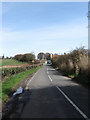
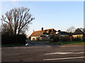
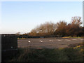
Top Road
The B2095 as it leaves the A259 and heads to Hooe. The Lamb Inn is the building partially obscured by vegetation.
Image: © Simon Carey
Taken: 6 Apr 2010
0.03 miles
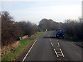
9
Sewer Bridge
Carrying Marsh Road, the A259, over Waterlot Stream.
Image: © Simon Carey
Taken: 6 Feb 2010
0.06 miles
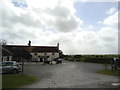
10
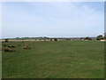
Sewers Marsh (1)
The name of the field according to the 1839 tithe map and part of the Pevensey Levels. This is the southern portion of the field which lies between Waterlot and Pinnock Streams.
Image: © Simon Carey
Taken: 6 Apr 2010
0.07 miles