IMAGES TAKEN NEAR TO
Crouch Lane, BATTLE, TN33 9EG
Introduction
This page details the photographs taken nearby to Crouch Lane, TN33 9EG by members of the Geograph project.
The Geograph project started in 2005 with the aim of publishing, organising and preserving representative images for every square kilometre of Great Britain, Ireland and the Isle of Man.

There are currently over 7.5m images from over14,400 individuals and you can help contribute to the project by visiting https://www.geograph.org.uk
Image Map (Loading...)


Getting Data...Please wait
Leaflet Map data © OpenStreetMap
Images are licensed for reuse under creativecommons.org/licenses/by-sa/2.0
Notes
- Clicking on the map will re-center to the selected point.
- The higher the marker number, the further away the image location is from the centre of the postcode.
Image Listing (15 Images Found)
Images are licensed for reuse under creativecommons.org/licenses/by-sa/2.0
Image
Details
Distance
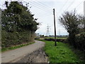
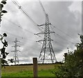
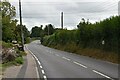
2
Pylons next to Crouch Lane
Crouch Lane beyond the southern edge of Ninfield links Bexhill Road (A269) with Lower Street (B2095).
Image: © Marathon
Taken: 5 Jun 2016
0.06 miles
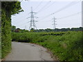
3
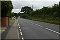
Crouch Lane
Crouch Lane beyond the southern edge of Ninfield links Bexhill Road (A269) with Lower Street (B2095).
Image: © Marathon
Taken: 5 Jun 2016
0.09 miles
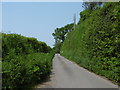
6
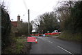
Roadworks on the B2095
These roadworks and temporary traffic lights were to enable workers to widen the road where the verges had encroached on to the highway.
Image: © Nigel Mykura
Taken: 12 Feb 2015
0.15 miles
7
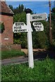
Old Direction Sign - Signpost by the B2095, Hooe Road, Ninfield parish
Black iron cap finial - 3 arms; East Sussex wood with number by the B2095, in parish of Ninfield (Wealden District), B2095 - Hooe Road, on grass triangle at junction with Crouch Lane.
Surveyed
Milestone Society National ID: SX_TQ7011A
Image: © Milestone Society
Taken: Unknown
0.16 miles
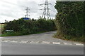
10

Old Direction Sign - Signpost by the A269, Bexhill Road, Ninfield parish
Black iron cap finial - 3 arms; East Sussex wood with number by the A269, in parish of Ninfield (Wealden District), Bexhill Road, in blackthorn hedge on East side of road, opposite junction with Crouch Lane.
Surveyed
Milestone Society National ID: SX_TQ7011B
Image: © Milestone Society
Taken: Unknown
0.18 miles