IMAGES TAKEN NEAR TO
Woodhams Close, BATTLE, TN33 0XE
Introduction
This page details the photographs taken nearby to Woodhams Close, TN33 0XE by members of the Geograph project.
The Geograph project started in 2005 with the aim of publishing, organising and preserving representative images for every square kilometre of Great Britain, Ireland and the Isle of Man.

There are currently over 7.5m images from over14,400 individuals and you can help contribute to the project by visiting https://www.geograph.org.uk
Image Map
Images are licensed for reuse under creativecommons.org/licenses/by-sa/2.0
Notes
- Clicking on the map will re-center to the selected point.
- The higher the marker number, the further away the image location is from the centre of the postcode.
Image Listing (324 Images Found)
Images are licensed for reuse under creativecommons.org/licenses/by-sa/2.0
Image
Details
Distance
1
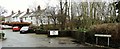
Woodhams Close
Tucked away between the market car park and Battle museum
Image: © Patrick Roper
Taken: 2 Feb 2017
0.01 miles
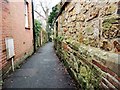
2
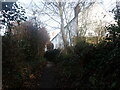
Western Avenue, Battle
This narrow footpath leads up from Guild Shaw to the High Street.
Image: © Marathon
Taken: 28 Jan 2024
0.02 miles
5
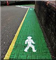
Newly painted pedestrian walkways, Market Square
These new designs are recommendations for where people might walk and, presumably, where vehicles must not go. When I took the picture none of the pedestrians in the square were keeping to the green painted pathways.
Image: © Patrick Roper
Taken: 2 Feb 2017
0.02 miles
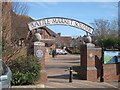
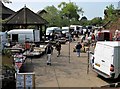
6

Market Square, Battle
Traders packing up Friday market in the Market Square. The building with the clock tower is Battle library.
Image: © Patrick Roper
Taken: 11 Nov 2016
0.02 miles
7
Shrub planting in Battle Market Square
The beds around the edge of the market square are sponsored by various organisations. This bed is on the eastern side of the square near the steps to the High Street. Note the bush of Lonicera 'Baggesen's Gold' to the right of the black post.
Image: © Patrick Roper
Taken: 2 Feb 2017
0.03 miles
8
Western Avenue
Western Avenue is a narrow footpath (in local dialect it would be called a twitten) leading from the northern end of Battle High Street. The ancient wall on the right is, presumably, the rear of The Almonry a Grade II Listed Building which houses Battle Museum.
Image: © Patrick Roper
Taken: 2 Feb 2017
0.03 miles
9
Looking south west down Western Avenue
Western Avenue is a narrow pedestrian path leading off Battle High Street.
Image: © Patrick Roper
Taken: 2 Feb 2017
0.03 miles
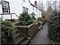
10
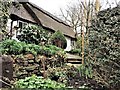
Little Thatch cottage in Western Avenue
Western Avenue is a lane leading from Battle High Street
Image: © Patrick Roper
Taken: 2 Feb 2017
0.03 miles