IMAGES TAKEN NEAR TO
Whatlington Road, BATTLE, TN33 0NF
Introduction
This page details the photographs taken nearby to Whatlington Road, TN33 0NF by members of the Geograph project.
The Geograph project started in 2005 with the aim of publishing, organising and preserving representative images for every square kilometre of Great Britain, Ireland and the Isle of Man.

There are currently over 7.5m images from over14,400 individuals and you can help contribute to the project by visiting https://www.geograph.org.uk
Image Map
Images are licensed for reuse under creativecommons.org/licenses/by-sa/2.0
Notes
- Clicking on the map will re-center to the selected point.
- The higher the marker number, the further away the image location is from the centre of the postcode.
Image Listing (59 Images Found)
Images are licensed for reuse under creativecommons.org/licenses/by-sa/2.0
Image
Details
Distance
1
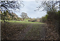
Field entrance off Whatlington Road
Most of the leaves have now fallen.
Image: © Peregrine
Taken: 7 Dec 2013
0.02 miles
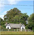
2
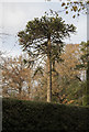
Monkey Puzzle Tree, Whatlington Road
Image: © Julian P Guffogg
Taken: 14 Dec 2013
0.04 miles
3
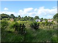
Cottage Field
The name of the field according to Whatlington's 1839 tithe map bounded to the south by the River Line, west by Whatlington Road and north by Leeford Cottages.
Image: © Simon Carey
Taken: 20 Aug 2019
0.05 miles
5
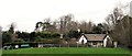
The Thatched Cottage, Whatlington Road
Note the Ferguson tractor on the right of the picture.
Image: © Patrick Roper
Taken: 29 Jan 2007
0.07 miles
6
The Thatched Cottage, Whatlington Road, Whatlington
Small cottage dating from the early 19th century.
Image: © Simon Carey
Taken: 20 Aug 2019
0.07 miles
7
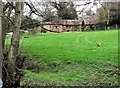
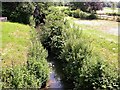
Brookfield in the Line valley, Whatlington
Image: © Patrick Roper
Taken: 29 Jan 2007
0.09 miles
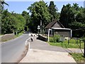
8
River Line from bridge on Whatlington Road, looking east
The river here runs between the village hall to the left and the parish car park. Some 2.5km downstream it changes its name to the river Brede
Image: © Patrick Roper
Taken: 29 Jun 2006
0.09 miles
9
Whatlington village hall by Whatlington Road
The road crosses the river Line just before the hall (see bridge on left of picture). The road joins the A21 just under a kilometre beyond this point
Image: © Patrick Roper
Taken: 29 Jun 2006
0.10 miles