IMAGES TAKEN NEAR TO
Netherfield Hill, BATTLE, TN33 0LF
Introduction
This page details the photographs taken nearby to Netherfield Hill, TN33 0LF by members of the Geograph project.
The Geograph project started in 2005 with the aim of publishing, organising and preserving representative images for every square kilometre of Great Britain, Ireland and the Isle of Man.

There are currently over 7.5m images from over14,400 individuals and you can help contribute to the project by visiting https://www.geograph.org.uk
Image Map (Loading...)


Getting Data...Please wait
Leaflet Map data © OpenStreetMap
Images are licensed for reuse under creativecommons.org/licenses/by-sa/2.0
Notes
- Clicking on the map will re-center to the selected point.
- The higher the marker number, the further away the image location is from the centre of the postcode.
Image Listing (3 Images Found)
Images are licensed for reuse under creativecommons.org/licenses/by-sa/2.0
Image
Details
Distance
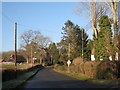
1
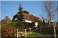
Baytree, Netherfield Hill, Battle, East Sussex
Possibly an Oast House
Image: © Oast House Archive
Taken: 3 Jan 2009
0.09 miles
2
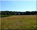
Little Meadow
The name of the field according to Battle's 1859 tithe map bounded by Beech Farm Lane to the north. Caldbec Hill is in the distance.
Image: © Simon Carey
Taken: 13 Aug 2022
0.20 miles