IMAGES TAKEN NEAR TO
High Street, ROBERTSBRIDGE, TN32 5AP
Introduction
This page details the photographs taken nearby to High Street, TN32 5AP by members of the Geograph project.
The Geograph project started in 2005 with the aim of publishing, organising and preserving representative images for every square kilometre of Great Britain, Ireland and the Isle of Man.

There are currently over 7.5m images from over14,400 individuals and you can help contribute to the project by visiting https://www.geograph.org.uk
Image Map
Images are licensed for reuse under creativecommons.org/licenses/by-sa/2.0
Notes
- Clicking on the map will re-center to the selected point.
- The higher the marker number, the further away the image location is from the centre of the postcode.
Image Listing (292 Images Found)
Images are licensed for reuse under creativecommons.org/licenses/by-sa/2.0
Image
Details
Distance
1
Weatherboarded Natwest bank, Robertsbridge
Image: © N Chadwick
Taken: 24 Dec 2008
0.01 miles
2
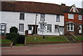
Half timbered houses, Robertsbridge
Grade II listed.
Image: © N Chadwick
Taken: 24 Dec 2008
0.01 miles
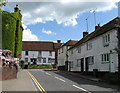
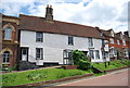
3
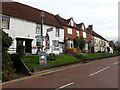
High Street, Robertsbridge
This attractive group is in High Street, opposite Station Road.
Image: © Marathon
Taken: 6 Nov 2021
0.01 miles
4
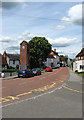
High Street
Taken from the entrance of the primary school with the war memorial/clock tower on the left. The road was once the A21 until the building of the by-pass in 1992.
Image: © Simon Carey
Taken: 3 May 2009
0.01 miles
5
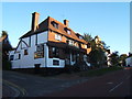
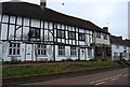
The Seven Stars Public House, Robertsbridge
Selling fine ales from Harveys of Lewes.
Image: © Barbara Carr
Taken: 21 Sep 2010
0.01 miles
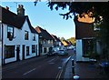
6
Raised Pavement, Robertsbridge
On the east side of the main street, the pavement is a good 3 feet above the roadway. Old buildings line, brick, stone and wood, line the scenic street which once bore the brunt of Hastings-London traffic.
.http://robertsbridge.east-sussex.co.uk/
Image: © Colin Smith
Taken: 14 Aug 2010
0.02 miles
7
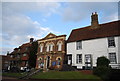
Robertsbridge United Reformed Church
Built in 1881.
Image: © N Chadwick
Taken: 19 Feb 2009
0.02 miles
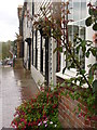
8
Cottages, Station Road
Looking towards the junction with High Street. Smugglers Cottage is on the right and Snugg Cottage to the left. Only the Nat West sign on the weatherboarded cottage ahead belies its use as a bank.
Image: © Simon Carey
Taken: 3 May 2009
0.02 miles
10
Robertsbridge
Main street through Robertsbridge.
Image: © Barbara Carr
Taken: 21 Sep 2010
0.02 miles