IMAGES TAKEN NEAR TO
Rye Road, RYE, TN31 7ST
Introduction
This page details the photographs taken nearby to Rye Road, TN31 7ST by members of the Geograph project.
The Geograph project started in 2005 with the aim of publishing, organising and preserving representative images for every square kilometre of Great Britain, Ireland and the Isle of Man.

There are currently over 7.5m images from over14,400 individuals and you can help contribute to the project by visiting https://www.geograph.org.uk
Image Map
Images are licensed for reuse under creativecommons.org/licenses/by-sa/2.0
Notes
- Clicking on the map will re-center to the selected point.
- The higher the marker number, the further away the image location is from the centre of the postcode.
Image Listing (22 Images Found)
Images are licensed for reuse under creativecommons.org/licenses/by-sa/2.0
Image
Details
Distance
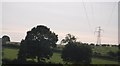
3
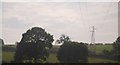
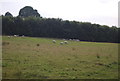
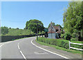
Lea Farm
A sizeable cluster of houses, barns and sheds. The map shows two paths leading through the farm towards Rye, but access is considered challenging.
Image: © David M Clark
Taken: 4 Jun 2023
0.05 miles
5
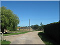
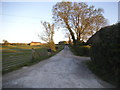
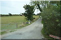
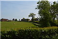
Track in Lea Farm
This farm track leads from Rye Road into the farm.
A footpath then leads towards Leasam Farm.
Image: © David Anstiss
Taken: 26 Jun 2011
0.06 miles