IMAGES TAKEN NEAR TO
Landgate, RYE, TN31 7LH
Introduction
This page details the photographs taken nearby to Landgate, TN31 7LH by members of the Geograph project.
The Geograph project started in 2005 with the aim of publishing, organising and preserving representative images for every square kilometre of Great Britain, Ireland and the Isle of Man.

There are currently over 7.5m images from over14,400 individuals and you can help contribute to the project by visiting https://www.geograph.org.uk
Image Map
Images are licensed for reuse under creativecommons.org/licenses/by-sa/2.0
Notes
- Clicking on the map will re-center to the selected point.
- The higher the marker number, the further away the image location is from the centre of the postcode.
Image Listing (1296 Images Found)
Images are licensed for reuse under creativecommons.org/licenses/by-sa/2.0
Image
Details
Distance
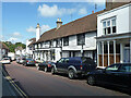
1
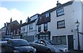
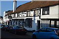
The Queen's Head, Rye
On the A268 Landgate (road). The houses along this road are Grade II listed (including the pub).
See http://www.britishlistedbuildings.co.uk/en-434576-15-24-rye for more details about the listed houses.
In the background is Rye's Landgate.
Image: © David Anstiss
Taken: 26 Jun 2011
0.00 miles
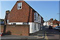
6
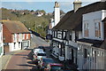
Landgate, Rye
The name of the street that is part of the A268 as it heads north from the Land Gate.
Image: © Simon Carey
Taken: 11 Apr 2019
0.01 miles
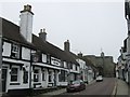
7
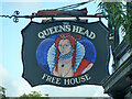
The Queens Head, Rye - inn sign
For the rest of the pub, see Image
Image: © Robin Webster
Taken: 29 May 2014
0.01 miles
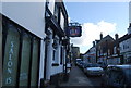
8
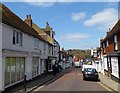
The Queens Head, Rye
A pub on Landgate.
Image: © Robin Webster
Taken: 29 May 2014
0.01 miles