IMAGES TAKEN NEAR TO
Hilltop Drive, RYE, TN31 7HT
Introduction
This page details the photographs taken nearby to Hilltop Drive, TN31 7HT by members of the Geograph project.
The Geograph project started in 2005 with the aim of publishing, organising and preserving representative images for every square kilometre of Great Britain, Ireland and the Isle of Man.

There are currently over 7.5m images from over14,400 individuals and you can help contribute to the project by visiting https://www.geograph.org.uk
Image Map
Images are licensed for reuse under creativecommons.org/licenses/by-sa/2.0
Notes
- Clicking on the map will re-center to the selected point.
- The higher the marker number, the further away the image location is from the centre of the postcode.
Image Listing (79 Images Found)
Images are licensed for reuse under creativecommons.org/licenses/by-sa/2.0
Image
Details
Distance
1
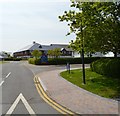
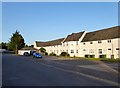
1-7, Highfields, Rye
A former nurses' block built in 1949 for the former Hill House Hospital has now been converted into residential units.
Image: © Simon Carey
Taken: 27 Jun 2019
0.01 miles
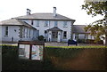
2
4-20, Hilltop Drive, Rye
Built as a workhouse in 1843-44 and remained so until 1929 after which it became known as The Retreat, a public assistance institution. In 1941 it was requisitioned by the military until the end of the war when it briefly became temporary homes for families made homeless by the war. In 1949 it was acquired by the National Health and became Hill House Hospital who used it for mental health patients. This closed in 1980 and remained disused for a number of years until converted into the current residential block.
Image: © Simon Carey
Taken: 27 Jun 2019
0.03 miles
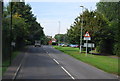
3
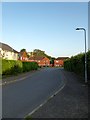
Hillcrest, Rye
Cul de sac off Hilltop Drive that runs around the southern side of Image
Image: © Simon Carey
Taken: 27 Jun 2019
0.04 miles
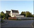
4
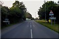
Rye Hill, Rye and Playden
The road signs back up the parish boundary arrangements here, all buildings on the western side are in Rye all those to the east belong to Playden. Rye Foreign is an old medieval term for an area north of the town that still remained in the French Abbey of Fecamp's hands after 1247.
Image: © Simon Carey
Taken: 27 Jun 2019
0.05 miles
6
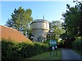
Water Tower, Rye Hill, Rye
Located on the access lane to Rye Cemetery.
Image: © Simon Carey
Taken: 22 Jun 2019
0.07 miles
7
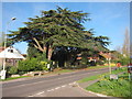
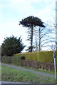
Tree on Rye Hill
Looking from Saltcote Lane junction.
Image: © Oast House Archive
Taken: 4 Apr 2011
0.08 miles