IMAGES TAKEN NEAR TO
Peasmarsh, RYE, TN31 6UX
Introduction
This page details the photographs taken nearby to TN31 6UX by members of the Geograph project.
The Geograph project started in 2005 with the aim of publishing, organising and preserving representative images for every square kilometre of Great Britain, Ireland and the Isle of Man.

There are currently over 7.5m images from over14,400 individuals and you can help contribute to the project by visiting https://www.geograph.org.uk
Image Map
Images are licensed for reuse under creativecommons.org/licenses/by-sa/2.0
Notes
- Clicking on the map will re-center to the selected point.
- The higher the marker number, the further away the image location is from the centre of the postcode.
Image Listing (28 Images Found)
Images are licensed for reuse under creativecommons.org/licenses/by-sa/2.0
Image
Details
Distance
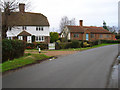
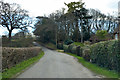
1
Tanhouse Lane
From left to right the buildings are Winton's Row, Rose Cottage and Winton's Bungalow.
Image: © Simon Carey
Taken: 21 Jul 2019
0.02 miles
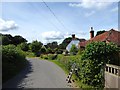
2
Rose Cottage, Tanhouse Lane
At the point where Tanhouse Lane turns sharply east. Rose Cottage is the weatherboarded two story building to the left. The smaller cottage is unnamed.
Image: © Simon Carey
Taken: 10 Feb 2007
0.03 miles
3
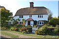
Rose Cottage
Tanhouse Lane, Peasmarsh
Image: © Julian P Guffogg
Taken: 27 Sep 2009
0.03 miles
4
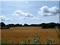
Yew Tree Field
The name of the field according to Peasmarsh's 1840 tithe map that is bounded by Mill Lane to the south and Tanhouse Lane to the east.
Image: © Simon Carey
Taken: 21 Jul 2019
0.07 miles
5
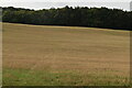
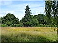
Furzy Field/Site of Furzy Shaw/Great Furzy Field
The name of the fields according to Peasmarsh's 1840 tithe map that have been merged to form a single unit. Furzy Field was in the foreground, Great Furzy Field can be seen on the slope in the distance whilst somewhere in the dip was Furzy Shaw which had been grubbed by the 1872 OS map. The house on the right is Wintons. The field is bounded to the west and south by Tanhouse Lane.
Image: © Simon Carey
Taken: 21 Jul 2019
0.07 miles
6
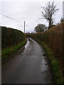
Mill Lane
Viewed from its junction with Tanhouse Lane. The highway heads west then north to Flackley Ash.
Image: © Simon Carey
Taken: 21 Jul 2019
0.07 miles
7
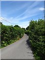
Mill Lane
Links Tanhouse Lane with the A268 at Flackley Ash.
Image: © Simon Carey
Taken: 10 Feb 2007
0.08 miles
9
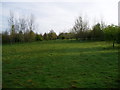
Footpath through plantation
Public footpath Peasmarsh 14b to Flackley Ash.
Image: © Peter Holmes
Taken: 30 Apr 2010
0.11 miles