IMAGES TAKEN NEAR TO
Watts Palace Lane, RYE, TN31 6FJ
Introduction
This page details the photographs taken nearby to Watts Palace Lane, TN31 6FJ by members of the Geograph project.
The Geograph project started in 2005 with the aim of publishing, organising and preserving representative images for every square kilometre of Great Britain, Ireland and the Isle of Man.

There are currently over 7.5m images from over14,400 individuals and you can help contribute to the project by visiting https://www.geograph.org.uk
Image Map
Images are licensed for reuse under creativecommons.org/licenses/by-sa/2.0
Notes
- Clicking on the map will re-center to the selected point.
- The higher the marker number, the further away the image location is from the centre of the postcode.
Image Listing (21 Images Found)
Images are licensed for reuse under creativecommons.org/licenses/by-sa/2.0
Image
Details
Distance
1
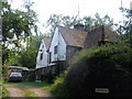
Watts Palace Cottage
Grade listed cottage on Watts Palace Lane.
See http://www.britishlistedbuildings.co.uk/en-409549-watts-palace-cottage-ewhurst-east-sussex for more details.
Image: © David Anstiss
Taken: 3 Aug 2013
0.01 miles
2
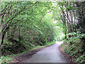
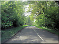
Watts Palace Lane, in Hoath Wood
Get off the main road and you are immediately into a different world.
Image: © RH Dengate
Taken: 31 May 2007
0.11 miles
3
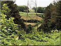
The Tillingham Valley from Brede High Woods
This is about the only view northwards across the upper Tillingham Valley from Brede High Woods, a property owned and managed by the woodland trust. Clearing the vegetation beneath the transmission lines preserves the view.
Image: © Patrick Roper
Taken: 20 Jun 2014
0.12 miles
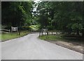
8
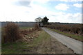
Coneyburrow Wood carpark
On the B2089 (between Cripp's Corner and Goatherd Green).
Image: © David Anstiss
Taken: 3 Aug 2013
0.19 miles
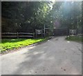
9
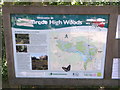
Brede High Woods Information Sign
Beside the woodland carpark on the B2089 (between Cripp's Corner and Goatherd Green).
Image: © David Anstiss
Taken: 3 Aug 2013
0.19 miles
10
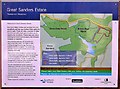
Old sign in Brede High Woods for Great Sanders Estate
This sign was put up by Southern Water before Brede High Woods was sold to the Woodland Trust, who now manage the green areas of site south of the main road. The grey areas are largely privately owned
Image: © Patrick Roper
Taken: 18 Apr 2006
0.20 miles