IMAGES TAKEN NEAR TO
Appledore Road, TENTERDEN, TN30 7DG
Introduction
This page details the photographs taken nearby to Appledore Road, TN30 7DG by members of the Geograph project.
The Geograph project started in 2005 with the aim of publishing, organising and preserving representative images for every square kilometre of Great Britain, Ireland and the Isle of Man.

There are currently over 7.5m images from over14,400 individuals and you can help contribute to the project by visiting https://www.geograph.org.uk
Image Map
Images are licensed for reuse under creativecommons.org/licenses/by-sa/2.0
Notes
- Clicking on the map will re-center to the selected point.
- The higher the marker number, the further away the image location is from the centre of the postcode.
Image Listing (9 Images Found)
Images are licensed for reuse under creativecommons.org/licenses/by-sa/2.0
Image
Details
Distance
1
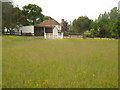
Tassels, Kench Hill
House as seen from a footpath around the house from Appledore Road to Finchbourne Wood.
Image: © David Anstiss
Taken: 13 Jun 2010
0.17 miles
2
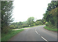
Footpath near Tassels
A footpath from Appledore Road leads past a house on Kench Hill leading to Finchbourne Wood and back to Appledore Road near Reading Street. On the right is an access drive to the house.
Image: © David Anstiss
Taken: 13 Jun 2010
0.19 miles
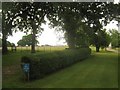
3
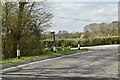
Footpath diversion
The OS maps show the public footpath going up the drive on the right towards a house called Tassels. A diversion route crosses the stile on the right and through a field, avoiding the house. The diversion is very well marked at this end (blue sign), but not so at the other end, although the route across the field is close- mown and very clear and easy to follow, once one twigs this is for the public's benefit. There are no official diversion signs, so is it official? Kent CC do not have on-line definitive maps, unlike some more progressive counties.
Image: © Robin Webster
Taken: 22 Apr 2007
0.19 miles
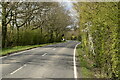
6
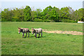
Donkeys
The public footpath is diverted past Tassels across a field occupied by two donkeys, who were interested to see a visitor. The B2080 is behind the hedge.
Image: © Robin Webster
Taken: 22 Apr 2007
0.23 miles
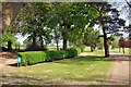
8
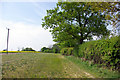
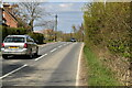
Footpath towards Leigh Green
The trees at the end of the hedge line are associated with a house called Tassels, where the footpath has been diverted away from the line shown on current OS maps and away from the house.
Image: © Robin Webster
Taken: 22 Apr 2007
0.23 miles