IMAGES TAKEN NEAR TO
Shrubcote, TENTERDEN, TN30 7BL
Introduction
This page details the photographs taken nearby to Shrubcote, TN30 7BL by members of the Geograph project.
The Geograph project started in 2005 with the aim of publishing, organising and preserving representative images for every square kilometre of Great Britain, Ireland and the Isle of Man.

There are currently over 7.5m images from over14,400 individuals and you can help contribute to the project by visiting https://www.geograph.org.uk
Image Map (Loading...)


Getting Data...Please wait
Leaflet Map data © OpenStreetMap
Images are licensed for reuse under creativecommons.org/licenses/by-sa/2.0
Notes
- Clicking on the map will re-center to the selected point.
- The higher the marker number, the further away the image location is from the centre of the postcode.
Image Listing (48 Images Found)
Images are licensed for reuse under creativecommons.org/licenses/by-sa/2.0
Image
Details
Distance
2
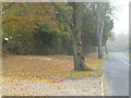
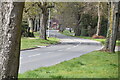
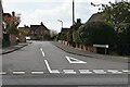
Appledore Road Tenterden
A misty autumn morning
Image: © Ron Lee
Taken: 1 Nov 2016
0.08 miles
4
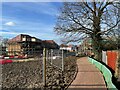
Footpath towards Tenterden
A path leads from Belcot Manor Farm access road towards Tenterden Recreational Ground. On the left is Belgar Farm Oast House. In the background is Image
Image: © David Anstiss
Taken: 13 Jun 2010
0.10 miles
8
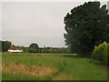
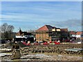
Oast House, in Belgar, near Tenterden
Flat fields at the back of housing estates.
Image: © Barry Hunter
Taken: 4 Feb 2007
0.10 miles
10
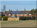
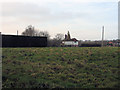
Back of houses on Shrubcote
There is a good roughly southern aspect for the solar panels.
Image: © Robin Webster
Taken: 22 Mar 2012
0.11 miles