IMAGES TAKEN NEAR TO
Ox Lane, TENTERDEN, TN30 6NG
Introduction
This page details the photographs taken nearby to Ox Lane, TN30 6NG by members of the Geograph project.
The Geograph project started in 2005 with the aim of publishing, organising and preserving representative images for every square kilometre of Great Britain, Ireland and the Isle of Man.

There are currently over 7.5m images from over14,400 individuals and you can help contribute to the project by visiting https://www.geograph.org.uk
Image Map (Loading...)


Getting Data...Please wait
Leaflet Map data © OpenStreetMap
Images are licensed for reuse under creativecommons.org/licenses/by-sa/2.0
Notes
- Clicking on the map will re-center to the selected point.
- The higher the marker number, the further away the image location is from the centre of the postcode.
Image Listing (48 Images Found)
Images are licensed for reuse under creativecommons.org/licenses/by-sa/2.0
Image
Details
Distance
4
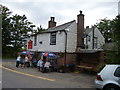
Tenterden: The 'Fat Ox'
A busy public house on the fringes of this small Kentish town
Image: © Dr Neil Clifton
Taken: 29 Aug 2015
0.07 miles
5
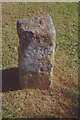
Old Milestone by the A28, Ashford Road, Tenterden Parish
Stone post (plate lost) by the A28, in parish of TENTERDEN (ASHFORD District), Ashford Road; at junction with Chalk Avenue, on bund forming verge, on West side of road. Tenterden marker, erected by the Bethersden turnpike trust in the 19th century.
Inscription once read:-
(Ashford 11)
(Tenterden 1)
Kent HER listed. HER Number: TQ 83 SE 285
https://www.heritagegateway.org.uk/Gateway/Results_Single.aspx?uid=MKE78196&resourceID=1005
Milestone Society National ID: KE_TTAF02.
Image: © C Woodward
Taken: 17 Jul 2008
0.08 miles
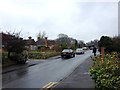
6
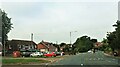
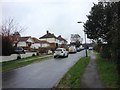
Ashford Road between Tenterden and St. Michael's
Image: © Patrick Roper
Taken: 20 Sep 2021
0.08 miles
7
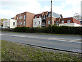
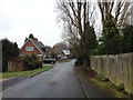
The Spires, Ashford Road, St Michael?s
See Image for when the site was being developed.
Image: © John Baker
Taken: 14 Apr 2019
0.08 miles
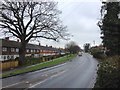
10
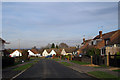
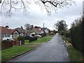
Springfield Avenue, St Michaels, Kent
Image: © Oast House Archive
Taken: 1 Dec 2008
0.09 miles