IMAGES TAKEN NEAR TO
Rhee Wall, ROMNEY MARSH, TN29 9TG
Introduction
This page details the photographs taken nearby to Rhee Wall, TN29 9TG by members of the Geograph project.
The Geograph project started in 2005 with the aim of publishing, organising and preserving representative images for every square kilometre of Great Britain, Ireland and the Isle of Man.

There are currently over 7.5m images from over14,400 individuals and you can help contribute to the project by visiting https://www.geograph.org.uk
Image Map
Images are licensed for reuse under creativecommons.org/licenses/by-sa/2.0
Notes
- Clicking on the map will re-center to the selected point.
- The higher the marker number, the further away the image location is from the centre of the postcode.
Image Listing (36 Images Found)
Images are licensed for reuse under creativecommons.org/licenses/by-sa/2.0
Image
Details
Distance
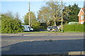
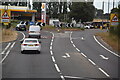
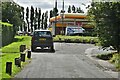
2
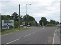
Brenzett Roundabout
The B2080 Rhee Wall from Appledore, meets the A259 heading right towards Rye and Brookland, or it heads straight on towards New Romney. The A2070 heads left towards Ashford.
Image: © David Anstiss
Taken: 29 Aug 2010
0.02 miles
3
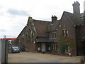
Brenzett Old School
On the B2080 Rhee Wall, beside the Brenzett Roundabout.
Now converted into several houses.
Image: © David Anstiss
Taken: 29 Aug 2010
0.02 miles
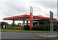
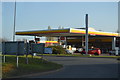
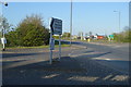
9
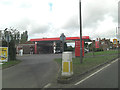
A259 Brenzett Roundabout Total Service Station
Image: © Stuart Logan
Taken: 25 Aug 2011
0.04 miles