IMAGES TAKEN NEAR TO
Queensway, ROMNEY MARSH, TN29 9HJ
Introduction
This page details the photographs taken nearby to Queensway, TN29 9HJ by members of the Geograph project.
The Geograph project started in 2005 with the aim of publishing, organising and preserving representative images for every square kilometre of Great Britain, Ireland and the Isle of Man.

There are currently over 7.5m images from over14,400 individuals and you can help contribute to the project by visiting https://www.geograph.org.uk
Image Map (Loading...)


Getting Data...Please wait
Leaflet Map data © OpenStreetMap
Images are licensed for reuse under creativecommons.org/licenses/by-sa/2.0
Notes
- Clicking on the map will re-center to the selected point.
- The higher the marker number, the further away the image location is from the centre of the postcode.
Image Listing (369 Images Found)
Images are licensed for reuse under creativecommons.org/licenses/by-sa/2.0
Image
Details
Distance
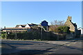
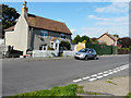
2
The Magpies, Queens Road
Planning permission has been granted, with conditions, by Folkestone and Hythe District Council under application number23/0141/FH for a “proposed double garage by side & conversion of existing garage to residential”.
Image: © John Baker
Taken: 2 Apr 2023
0.07 miles
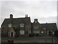
3
Lydd old fire station
Lydd old fire station, Museum, Queens Road, Lydd, Romney Marsh, Kent, which was in use from 1890 to 1973, is now the town's museum
Image: © Kevin Hale
Taken: 28 Apr 2009
0.07 miles


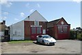
7
Lydd Library
On Skinner Street. In the old Lydd Primary School.
The new school has been built around the old school buildings.
Image: © David Anstiss
Taken: 23 Jan 2011
0.09 miles
8
East End Cottage, Park Street
The green hoarding, to its right, hides the former site of the Royal British Legion clubhouse and outbuildings. Planning permission has been approved, with conditions, by Folkestone and Hythe District Council under application number Y15/0315/SH for the “erection of two semi-detached dwellings together with garages, associated parking and vehicular access following demolition of former clubhouse and outbuildings”. There will also be access to the houses from the High Street to the left of Image
Image: © John Baker
Taken: 20 Sep 2015
0.10 miles
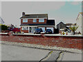
9
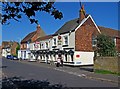
Royal Mail (public house) (1), 8 Park Street
Located on the corner of Park Street and Bleak Road. It is a Shepherd Neame house. They are Britain's oldest brewers, having commenced business in 1698, in Faversham, Kent. They are a family run business, and the Neame family have been involved continuously since 1864 up to the present day. They now have over 360 pubs.
History of the company: http://www.shepherd-neame.co.uk/company/history.htm
GeoGraph article: http://www.geograph.org.uk/article/Shepherd-Neame
Image
Image
Image: © P L Chadwick
Taken: 24 May 2010
0.10 miles
10
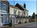
Royal Mail (public house) (2), 8 Park Street
It is a Shepherd Neame house. They are Britain's oldest brewers, having commenced business in 1698, in Faversham, Kent. They are a family run business, and the Neame family have been involved continuously since 1864 up to the present day. They now have over 360 pubs. According to their website, this pub caters mainly for the local community, although visitors are welcome.
History of the company: http://www.shepherd-neame.co.uk/company/history.htm
GeoGraph article: http://www.geograph.org.uk/article/Shepherd-Neame
Image
Image
Image: © P L Chadwick
Taken: 24 May 2010
0.10 miles