IMAGES TAKEN NEAR TO
Willow Drive, ROMNEY MARSH, TN29 0SX
Introduction
This page details the photographs taken nearby to Willow Drive, TN29 0SX by members of the Geograph project.
The Geograph project started in 2005 with the aim of publishing, organising and preserving representative images for every square kilometre of Great Britain, Ireland and the Isle of Man.

There are currently over 7.5m images from over14,400 individuals and you can help contribute to the project by visiting https://www.geograph.org.uk
Image Map (Loading...)


Getting Data...Please wait
Leaflet Map data © OpenStreetMap
Images are licensed for reuse under creativecommons.org/licenses/by-sa/2.0
Notes
- Clicking on the map will re-center to the selected point.
- The higher the marker number, the further away the image location is from the centre of the postcode.
Image Listing (121 Images Found)
Images are licensed for reuse under creativecommons.org/licenses/by-sa/2.0
Image
Details
Distance
1
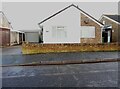
64, Laurel Avenue
Planning permission has been approved, with conditions, by Folkestone and Hythe District Council under application number 22/1564/FH for the “erection of single storey side extension following removal of detached garage”.
Image: © John Baker
Taken: 28 Nov 2022
0.09 miles
2
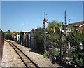
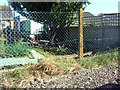
Up The Pole, St Mary's Bay
The railway runs along behind the houses on Laurel Avenue on the edge of St Mary's Bay village.
Someone has made a flower pot man figure climbing up a pole. Fixing a light, by the look of it.
Image: © Des Blenkinsopp
Taken: 16 Jun 2021
0.10 miles
3
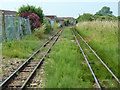
RH&DR, St. Mary's Bay
The Romney, Hythe and Dymchurch Railway runs behind the back gardens of Laurel Avenue.
Image: © Robin Webster
Taken: 13 Jul 2013
0.11 miles
4
RH&DR, St. Mary's Bay
The Romney, Hythe and Dymchurch Railway skirts around the back gardens of Laurel Avenue.
Image: © Robin Webster
Taken: 13 Jul 2013
0.11 miles
5
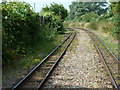
RH&DR, St. Mary's Bay
The Romney, Hythe and Dymchurch Railway skirts around the back gardens of Laurel Avenue.
Image: © Robin Webster
Taken: 13 Jul 2013
0.11 miles
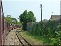
6
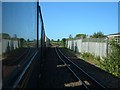
St Mary's Bay - 2013
St Mary's Bay, Kent, Romney, Hythe & Dymchurch Railway
Image: © Helmut Zozmann
Taken: 27 Aug 2013
0.12 miles
7
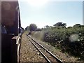
St Mary's Bay - 2008
St Mary's Bay seen from the Romney, Hythe & Dymchurch Railway.
Image: © Helmut Zozmann
Taken: 5 Jul 2008
0.12 miles
8
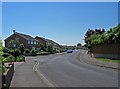
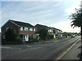
Maple Drive
This residential street could be anywhere, but it's in St. Mary's Bay, just off Jefferstone Lane, which is the main road through the village.
Image: © P L Chadwick
Taken: 24 May 2010
0.12 miles
10
St Mary's Bay - 2008
St Mary's Bay seen from the Romney, Hythe & Dymchurch Railway.
Image: © Helmut Zozmann
Taken: 5 Jul 2008
0.14 miles