IMAGES TAKEN NEAR TO
Anne Roper Close, NEW ROMNEY, TN28 8UA
Introduction
This page details the photographs taken nearby to Anne Roper Close, TN28 8UA by members of the Geograph project.
The Geograph project started in 2005 with the aim of publishing, organising and preserving representative images for every square kilometre of Great Britain, Ireland and the Isle of Man.

There are currently over 7.5m images from over14,400 individuals and you can help contribute to the project by visiting https://www.geograph.org.uk
Image Map (Loading...)


Getting Data...Please wait
Leaflet Map data © OpenStreetMap
Images are licensed for reuse under creativecommons.org/licenses/by-sa/2.0
Notes
- Clicking on the map will re-center to the selected point.
- The higher the marker number, the further away the image location is from the centre of the postcode.
Image Listing (63 Images Found)
Images are licensed for reuse under creativecommons.org/licenses/by-sa/2.0
Image
Details
Distance
1
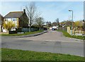
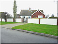
Anne Roper Close, Littlestone
This close is off St Andrew's Road. It was named after the local historian Miss Anne Roper see http://www.geograph.org.uk/photo/1793747
Image: © John Baker
Taken: 6 Apr 2010
0.04 miles
2
16, Cherry Gardens
Planning permission has been approved, with conditions, by Folkestone and Hythe District Council under application number 22/1479/FH for the “erection of a single storey side and rear extension follow demolition of existing conservatory”.
Image: © John Baker
Taken: 9 Nov 2022
0.05 miles
3
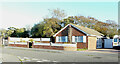
Brambles - north side
Planning permission has been granted, with conditions, by Folkestone and Hythe District Council under application number 22/1920/FH for a “single-storev side extension”. The extension will be constructed in place of the greenhouse.
Image: © John Baker
Taken: 29 Jan 2023
0.08 miles
4
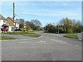
St Andrew's & Blenheim Road junction
In 1980, the junction was a mess of sand see http://www.geograph.org.uk/photo/1569557
Image: © John Baker
Taken: 6 Apr 2010
0.08 miles
5
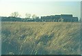
New housing in Blenheim Road: 1973
The whole area of open land has been built on since 1973.
Image: © John Baker
Taken: Unknown
0.08 miles
6
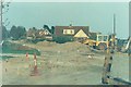
St Andrew's & Blenheim Road junction, 1980
The view shows mains drainage being installed. St Andrew's Road is to the left of the picture, Blenheim Road to the right.
Image: © John Baker
Taken: 6 Apr 1980
0.08 miles
7
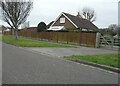
Brambles - east side
The view of Image shows where an extension is to be constructed.
Image: © John Baker
Taken: 8 Jan 2023
0.08 miles
8
Blenheim Road, Littlestone
In 1978 the road was unsealed and there were no houses on the right hand side of the picture see http://www.geograph.org.uk/photo/1713145
Image: © John Baker
Taken: 6 Apr 2010
0.10 miles
9
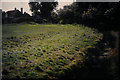
Nashe?s Run, 1970
Here looking towards the house, which used to be known as The Lodge, but was extended to become Littlestone Warren Golf Club. Aerial views show the grass has been built over. Like other Romney Marsh drains, Nashe’s Run has a bed of foul-smelling mud, if disturbed.
Image: © John Baker
Taken: Unknown
0.10 miles
10
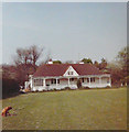
The Lodge, St Andrew?s Road in 1969
Taken by my father, George Baker, who was secretary at Littlestone Golf Club from 1968-1981; The Lodge was provided as accommodation, for the secretary, until it became Image As the veranda faced east, it was only suitable to be used on a really hot day, when there was little wind.
Image: © George Baker
Taken: Unknown
0.10 miles