IMAGES TAKEN NEAR TO
Fairfield Close, Rolfe Lane, NEW ROMNEY, TN28 8JA
Introduction
This page details the photographs taken nearby to Fairfield Close, Rolfe Lane, TN28 8JA by members of the Geograph project.
The Geograph project started in 2005 with the aim of publishing, organising and preserving representative images for every square kilometre of Great Britain, Ireland and the Isle of Man.

There are currently over 7.5m images from over14,400 individuals and you can help contribute to the project by visiting https://www.geograph.org.uk
Image Map (Loading...)


Getting Data...Please wait
Leaflet Map data © OpenStreetMap
Images are licensed for reuse under creativecommons.org/licenses/by-sa/2.0
Notes
- Clicking on the map will re-center to the selected point.
- The higher the marker number, the further away the image location is from the centre of the postcode.
Image Listing (397 Images Found)
Images are licensed for reuse under creativecommons.org/licenses/by-sa/2.0
Image
Details
Distance
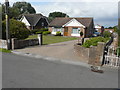
1
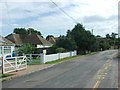
Fairfield House, New Romney
Grade II Listed Building on Fairfield Road, opposite Mabledon Close.
See http://www.britishlistedbuildings.co.uk/en-175021-fairfield-house-new-romney for more details on the house.
Image: © David Anstiss
Taken: 7 Nov 2010
0.04 miles
2
41, Rolfe Lane
Planning permission has been approved, with conditions, by Folkestone and Hythe District Council under application number 22/0544/FH for the “conversion of garage to living accommodation, including alteration of flat roof to pitched roof”.
Image: © John Baker
Taken: 7 Aug 2022
0.04 miles
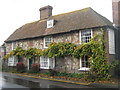
3
The Prince of Wales, Public House, New Romney
On the junction of Fairfield Road (in front) and George Lane (behind the pub).
Image: © David Anstiss
Taken: 7 Nov 2010
0.07 miles
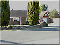
4
51, Rolfe Lane
Planning permission has been approved by Folkestone and Hythe District Council under application number Y14/0888/SH as the “certificate of lawful development for the proposed use of the garage for living accommodation and associated works including alterations to the roof to form a pitch” and Y13/1271/SH as the “certificate of proposed lawful development for the extension and alterations to existing detached garage”. The garage can be seen to the right of the bungalow.
Image: © John Baker
Taken: 16 Aug 2015
0.07 miles
5
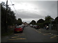
Fairfield Road, New Romney
Looking towards the town centre from the junction with Craythorne Lane. The large quantity of parked cars is explained by the fact that the picture was taken on the day of the New Romney Country Fayre, whose PA system was audible from here.
Image: © Richard Vince
Taken: 29 Jul 2017
0.09 miles
7
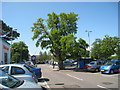
Tree in Sainsbury's Carpark, New Romney
Image: © Oast House Archive
Taken: 29 May 2009
0.09 miles
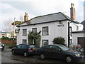
8
High House, High Street
An early 19th century, grade II, listed house https://britishlistedbuildings.co.uk/101025292-high-house-new-romney#.Yh0bwSvP3cc which appears to be undergoing a major refurbishment.
A similar view of Image from the southwest.
Image: © John Baker
Taken: 6 Feb 2022
0.10 miles
9
High House, High Street
An early 19th century, grade II, listed house https://britishlistedbuildings.co.uk/101025292-high-house-new-romney#.Yh0bwSvP3cc which appears to be undergoing a major refurbishment.
A similar view of Image from the east-northeast.
Image: © John Baker
Taken: 6 Feb 2022
0.10 miles