IMAGES TAKEN NEAR TO
Marsh View Close, NEW ROMNEY, TN28 8AG
Introduction
This page details the photographs taken nearby to Marsh View Close, TN28 8AG by members of the Geograph project.
The Geograph project started in 2005 with the aim of publishing, organising and preserving representative images for every square kilometre of Great Britain, Ireland and the Isle of Man.

There are currently over 7.5m images from over14,400 individuals and you can help contribute to the project by visiting https://www.geograph.org.uk
Image Map
Images are licensed for reuse under creativecommons.org/licenses/by-sa/2.0
Notes
- Clicking on the map will re-center to the selected point.
- The higher the marker number, the further away the image location is from the centre of the postcode.
Image Listing (224 Images Found)
Images are licensed for reuse under creativecommons.org/licenses/by-sa/2.0
Image
Details
Distance
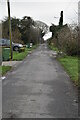
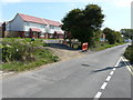
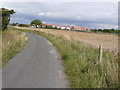
1
Church Lane, New Romney in 1972
The lane runs from New Romney as far as the track of the Romney, Hythe and Dymchurch Railway. The way thereon is along a footpath across the railway to eventually join Dunes Road, which emerges on the Greatstone seafront at the Jolly Fisherman public house.
Image: © John Baker
Taken: Unknown
0.03 miles
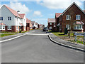
2
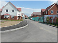
Church Lane, Marsh View
The development is to be known as Marsh View. Planning permission was approved, with conditions, by Folkestone and Hythe District Council under application number Y08/1002/SH for the “erection of sixty dwellings and associated infrastructure being details pursuant to outline permission Y05/0258/SH (matters relating to siting, design, external appearance, access and landscaping) and approval of conditions 6, 7, 10, 11, 12 and 14”. The council describes the site as Allotment Gardens and the development may be being built on former allotment gardens, as there are some, that are known as Church Lane Allotment Gardens and Gardening Services, further along the lane beyond the development.
Image: © John Baker
Taken: 16 Aug 2015
0.03 miles
3
Looking east from Church Lane
Towards part of a new development of houses known as Marsh View. Planning permission was approved, with conditions, by Folkestone and Hythe District Council under application number Y08/1002/SH for the “erection of sixty dwellings and associated infrastructure being details pursuant to outline permission Y05/0258/SH (matters relating to siting, design, external appearance, access and landscaping) and approval of conditions 6, 7, 10, 11, 12 and 14”. The council describes the site as Allotment Gardens and the development may be being built on former allotment gardens, as there are some, that are known as Church Lane Allotment Gardens and Gardening Services, further along the lane beyond the development.
Image: © John Baker
Taken: 16 Aug 2015
0.03 miles
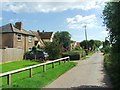
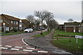
4
Church Lane, Marsh View
Marsh View is the name of the estate on which this road lies. Belle View Close is the next road to the right, just beyond the parked car.
Image: © John Baker
Taken: 4 May 2016
0.04 miles
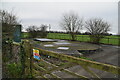
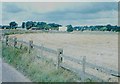
5
Looking north from Church Lane
Towards the southern perimeter of the development known as Marsh View. Planning permission was approved, with conditions, by Folkestone and Hythe District Council under application number Y08/1002/SH for the “erection of sixty dwellings and associated infrastructure being details pursuant to outline permission Y05/0258/SH (matters relating to siting, design, external appearance, access and landscaping) and approval of conditions 6, 7, 10, 11, 12 and 14”. The council describes the site as Allotment Gardens and the development may be being built on former allotment gardens, as there are some to the left of the solitary tree, that are known as Church Lane Allotment Gardens and Gardening Services.
Image: © John Baker
Taken: 16 Aug 2015
0.05 miles