IMAGES TAKEN NEAR TO
Biddenden, ASHFORD, TN27 8DN
Introduction
This page details the photographs taken nearby to TN27 8DN by members of the Geograph project.
The Geograph project started in 2005 with the aim of publishing, organising and preserving representative images for every square kilometre of Great Britain, Ireland and the Isle of Man.

There are currently over 7.5m images from over14,400 individuals and you can help contribute to the project by visiting https://www.geograph.org.uk
Image Map
Images are licensed for reuse under creativecommons.org/licenses/by-sa/2.0
Notes
- Clicking on the map will re-center to the selected point.
- The higher the marker number, the further away the image location is from the centre of the postcode.
Image Listing (4 Images Found)
Images are licensed for reuse under creativecommons.org/licenses/by-sa/2.0
Image
Details
Distance
1
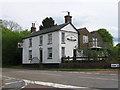
Castletons Oak Public House
On junction of Tenterden Road (in front) and Benenden Road (on right).
Note; strange pub sign, man sitting on a coffin!!
Image: © David Anstiss
Taken: 3 May 2009
0.13 miles
2
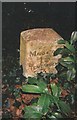
Old Milestone by Tenterden Road, Biddenden parish
Carved stone post by the UC road, in parish of Biddenden (Ashford District), Tenterden Road, South of "Castleton's Oak" PH, near Brogues Wood, just North of gate, in shrubbery with ivy cover, on West side of road. Biddenden stone, erected by the Biddenden turnpike trust in the 19th century.
Inscription reads:-
MAIDSTONE
15
TENTERDEN
3
Rivet benchmark on top.
Milestone Society National ID: KE_MDTD15
Image: © C Woodward
Taken: 9 May 2013
0.18 miles

4
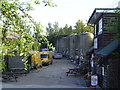
Biddenden Cider
The cider tanks at Biddenden vineyard
Image: © John Brown
Taken: 29 Aug 2005
0.25 miles