IMAGES TAKEN NEAR TO
Pilgrims Way, ASHFORD, TN27 0DR
Introduction
This page details the photographs taken nearby to Pilgrims Way, TN27 0DR by members of the Geograph project.
The Geograph project started in 2005 with the aim of publishing, organising and preserving representative images for every square kilometre of Great Britain, Ireland and the Isle of Man.

There are currently over 7.5m images from over14,400 individuals and you can help contribute to the project by visiting https://www.geograph.org.uk
Image Map
Images are licensed for reuse under creativecommons.org/licenses/by-sa/2.0
Notes
- Clicking on the map will re-center to the selected point.
- The higher the marker number, the further away the image location is from the centre of the postcode.
Image Listing (27 Images Found)
Images are licensed for reuse under creativecommons.org/licenses/by-sa/2.0
Image
Details
Distance
1
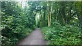
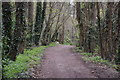
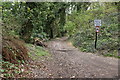
Bridleway Section of the North Downs Way
Quite a long section runs through dense woodland with a few glimpses of field along the way.
Image: © James Emmans
Taken: 12 Jul 2014
0.01 miles
4
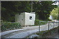
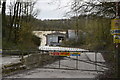
Weighbridge at Charing chalk quarry
medium sized weighbridge on ramps
Image: © Mike Sharpe
Taken: 18 Sep 2011
0.04 miles
6
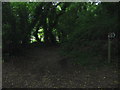
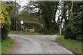
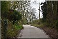
Byway to Squids Gate
This byway leads from the Pilgrims Way (and the North Downs Way - long distance footpath), to Squids Gate Lane, near Burnt Oak Farm.
Image: © David Anstiss
Taken: 28 May 2009
0.05 miles