IMAGES TAKEN NEAR TO
Wind Hill, ASHFORD, TN27 0BD
Introduction
This page details the photographs taken nearby to Wind Hill, TN27 0BD by members of the Geograph project.
The Geograph project started in 2005 with the aim of publishing, organising and preserving representative images for every square kilometre of Great Britain, Ireland and the Isle of Man.

There are currently over 7.5m images from over14,400 individuals and you can help contribute to the project by visiting https://www.geograph.org.uk
Image Map (30 Images)


Getting Data...Please wait
Leaflet Map data © OpenStreetMap
Images are licensed for reuse under creativecommons.org/licenses/by-sa/2.0
Notes
- Clicking on the map will re-center to the selected point.
- The higher the marker number, the further away the image location is from the centre of the postcode.
Image Listing (30 Images Found)
Images are licensed for reuse under creativecommons.org/licenses/by-sa/2.0
Image
Details
Distance
2
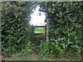
Stile in hedge on Tile Lodge Road
Two paths lead over this stile. A path leads left to Church Hill Road. A path also leads right to Burleigh Farm and Cherry Farm.
Image: © David Anstiss
Taken: 28 May 2009
0.09 miles
3
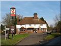
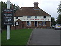
The Red Lion (spot the difference)
In the 29 months since the previous photo Image, a large bush has been cut down to reveal the porch, and umbrellas provided on the terrace (less use in January than they would have been in August - the pub's real log fire was much more of an attraction on this occasion!)
Image: © Stephen Craven
Taken: 30 Jan 2009
0.09 miles
9
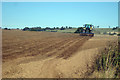
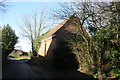
Discing at Burleigh Farm
Once the field has been ploughed the furrows are broken down to level the ground once again.
Image: © Oast House Archive
Taken: 22 Sep 2009
0.12 miles
10

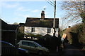
The Red Lion, public House, Charing Heath
On the junction of the Lodge Road (on the left) and Egerton Road (unseen,to the right). This 16th Century Inn is part of Shepherd Neame pub chain.
Image: © David Anstiss
Taken: 17 Oct 2010
0.12 miles