IMAGES TAKEN NEAR TO
Hook Lane, ASHFORD, TN27 0AN
Introduction
This page details the photographs taken nearby to Hook Lane, TN27 0AN by members of the Geograph project.
The Geograph project started in 2005 with the aim of publishing, organising and preserving representative images for every square kilometre of Great Britain, Ireland and the Isle of Man.

There are currently over 7.5m images from over14,400 individuals and you can help contribute to the project by visiting https://www.geograph.org.uk
Image Map
Images are licensed for reuse under creativecommons.org/licenses/by-sa/2.0
Notes
- Clicking on the map will re-center to the selected point.
- The higher the marker number, the further away the image location is from the centre of the postcode.
Image Listing (10 Images Found)
Images are licensed for reuse under creativecommons.org/licenses/by-sa/2.0
Image
Details
Distance
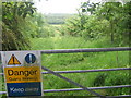
1
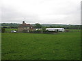
Little Hook Farm
On access road from Hook Lane. Seen from footpath from Hook Lane to Hitherfield in Charing.
Image: © David Anstiss
Taken: 28 May 2009
0.11 miles
2
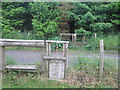
Footpath crosses Hook Lane
Two stiles and two dog gates are on this footpath from Tile Lodge Road, past working quarry, the path leads past a disused quarry (hidden in conifers) to Hitherfield in Charing.
Image: © David Anstiss
Taken: 28 May 2009
0.11 miles
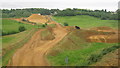
3
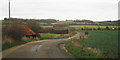
Great Hook, Charing
On Hook Lane heading towards the A20 Maidstone Road.
Image: © Oast House Archive
Taken: 1 Dec 2009
0.12 miles
4
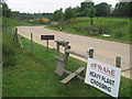
Footpath crosses quarry access road
Footpath from Hook Lane, passes over road, then around the quarry to Tile Lodge Road.
Image: © David Anstiss
Taken: 28 May 2009
0.14 miles
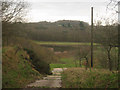
5
Disused Quarry near Little Hook Farm
This former quarry pit, near the farm is not accessible officially, but paths lead in from the public footpath from Hook land to Hitherfield in Charing.
Image: © David Anstiss
Taken: 28 May 2009
0.14 miles
6
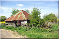
Derelict building by Great Hook
This building with door opening onto the public lane is called a sheepfold by the OS.
Image: © Robin Webster
Taken: 21 Apr 2007
0.14 miles
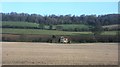
7

Great Hook
The backdrop is the scarp of the North Downs.
Image: © Robin Webster
Taken: 21 Apr 2007
0.17 miles
8
Disused Quarry
Near to Little Hook Farm.
Image: © Oast House Archive
Taken: 1 Dec 2009
0.20 miles
10
View from footbridge in Sand Quarry
This quarry owned by Brett Aggregates is on Hook Lane. The bridge is on a path from Charing Heath Road, over and around the quarry to Hook Lane.
Image: © David Anstiss
Taken: 28 May 2009
0.24 miles