IMAGES TAKEN NEAR TO
Ashford Road, ASHFORD, TN26 3LJ
Introduction
This page details the photographs taken nearby to Ashford Road, TN26 3LJ by members of the Geograph project.
The Geograph project started in 2005 with the aim of publishing, organising and preserving representative images for every square kilometre of Great Britain, Ireland and the Isle of Man.

There are currently over 7.5m images from over14,400 individuals and you can help contribute to the project by visiting https://www.geograph.org.uk
Image Map
Images are licensed for reuse under creativecommons.org/licenses/by-sa/2.0
Notes
- Clicking on the map will re-center to the selected point.
- The higher the marker number, the further away the image location is from the centre of the postcode.
Image Listing (6 Images Found)
Images are licensed for reuse under creativecommons.org/licenses/by-sa/2.0
Image
Details
Distance
1
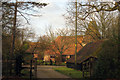
Tanden Oast, Ashford Road, High Halden, Kent
Image: © Oast House Archive
Taken: 27 Jan 2009
0.07 miles
2
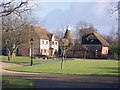
Tanden
Large house and Oast House near the A28 Ashford Road.
Image: © David Anstiss
Taken: 24 Jan 2010
0.11 miles
3
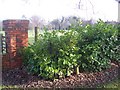
Stile in a hedge near Tanden
A footpath from Gadsby Lane, leads across many fields, then crosses an access drive to Tanden, then through the laurel hedge and beside the hedge towards the A28 Ashford Road.
Image: © David Anstiss
Taken: 24 Jan 2010
0.14 miles
4
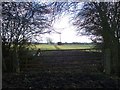
Gate near Middle Shaw
This gate is on a footpath from the A28 Ashford Road towards Marten Lane. Another path also heads right across a field towards Plurenden Road.
Image: © David Anstiss
Taken: 24 Jan 2010
0.23 miles
5
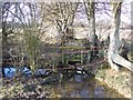
Stile near Marten Lane
This stile and broken footbridge are on a path from Marten Lane towards the A28 Ashford Road.
Image: © David Anstiss
Taken: 24 Jan 2010
0.24 miles
6
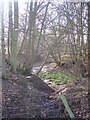
Pond in Middle Shaw
A pond leads to a stream running through this thin woodland towards Wayhill Shaw and then onto Silver Wood. Seen from a footpath from the A28 Ashford Road towards Plurenden Manor.
Image: © David Anstiss
Taken: 24 Jan 2010
0.24 miles