IMAGES TAKEN NEAR TO
Orchard Field, ASHFORD, TN26 3AW
Introduction
This page details the photographs taken nearby to Orchard Field, TN26 3AW by members of the Geograph project.
The Geograph project started in 2005 with the aim of publishing, organising and preserving representative images for every square kilometre of Great Britain, Ireland and the Isle of Man.

There are currently over 7.5m images from over14,400 individuals and you can help contribute to the project by visiting https://www.geograph.org.uk
Image Map
Images are licensed for reuse under creativecommons.org/licenses/by-sa/2.0
Notes
- Clicking on the map will re-center to the selected point.
- The higher the marker number, the further away the image location is from the centre of the postcode.
Image Listing (120 Images Found)
Images are licensed for reuse under creativecommons.org/licenses/by-sa/2.0
Image
Details
Distance
4

Bethersden Village Sign, Bethersden, Kent
Image: © Oast House Archive
Taken: 27 Jan 2009
0.07 miles
5
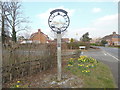
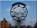
Bethersden Village Sign
This sign was erected for the Millennium and is located in School Road near the junction with the A28 Ashford Road. School Road can be seen to the right of the photo whilst behind the sign, Whiston Avenue branches off School Road.
Image: © David Hillas
Taken: 17 Mar 2016
0.08 miles
6
Close Up of the Bethersden Village Sign
This photo shows the eight symbols round the sign with St Margaret's Parish Church and a few houses in its centre.
Image: © David Hillas
Taken: 17 Mar 2016
0.08 miles
7
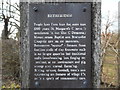
Notice on Bethersden Village Sign (1)
This photo shows one of four notices on the Bethersden Village Sign. It says the following:
BETHERSDEN
People have lived here for more than 1000 years. St Margaret's Church is mentioned in the 12th C Domesday Monachorum. Baptist and Methodist Chapels are more modern.
Bethersden "marble" - formed from fossilised shells of tiny freshwater snails is no longer quarried but traditional crafts (woodworking, iron forging etc) continue, as do horticulture and pig, sheep and cereal farming.
Riding, cricket, football, tennis and cycle-racing are features of village life, as is a spirit of community care.
Image: © David Hillas
Taken: 17 Mar 2016
0.08 miles
8
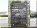
Notice on Bethersden Village Sign (3)
This photo shows one of the four notices on the Bethersden village sign in School Road near the A28 Ashford Road. It says the following:
THE SIGN SYMBOLS
OAST HOUSES - hop farming area until 1970s
ROCKING HORSE - Stevenson Brothers export them all over the world
ANVIL - forges in the parish still operational
BOOK - Richard Lovelace, 17th C Cavalier Poet, owned land in Bethersden. He wrote: "Stone walls do not a prison make
Nor i'ron bars a cage"
PLANE - village's wood craftmanship renowned.
SHEARS - sheep farming commercially important.
PIG - 1086 village named "Beadericesdenne". "denne" meant woodland where swine are pastured
Image: © David Hillas
Taken: 17 Mar 2016
0.08 miles
9
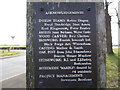
Notice on Bethersden Village Sign (4)
This notice is one of four on the Betherden Village Sign and lists the acknowledgements to those who were responsible for the sign being erected for the Millennium. Included on that list is the Bethersden "Marble" donated by 44 residents.
Image: © David Hillas
Taken: 17 Mar 2016
0.08 miles
