IMAGES TAKEN NEAR TO
Hamstreet, ASHFORD, TN26 2QP
Introduction
This page details the photographs taken nearby to TN26 2QP by members of the Geograph project.
The Geograph project started in 2005 with the aim of publishing, organising and preserving representative images for every square kilometre of Great Britain, Ireland and the Isle of Man.

There are currently over 7.5m images from over14,400 individuals and you can help contribute to the project by visiting https://www.geograph.org.uk
Image Map
Images are licensed for reuse under creativecommons.org/licenses/by-sa/2.0
Notes
- Clicking on the map will re-center to the selected point.
- The higher the marker number, the further away the image location is from the centre of the postcode.
Image Listing (17 Images Found)
Images are licensed for reuse under creativecommons.org/licenses/by-sa/2.0
Image
Details
Distance
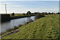
9
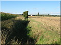
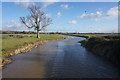
Ditch towards Meadow View
As seen from a footpath between Ham Mill Farm and Bridge Farm.
This ditch heads northwards to the cottages beside the Royal Military Canal.
On the left is a late crop of Sweetcorn.
Image: © David Anstiss
Taken: 29 Aug 2010
0.19 miles