IMAGES TAKEN NEAR TO
Bilsington Road, ASHFORD, TN26 2PD
Introduction
This page details the photographs taken nearby to Bilsington Road, TN26 2PD by members of the Geograph project.
The Geograph project started in 2005 with the aim of publishing, organising and preserving representative images for every square kilometre of Great Britain, Ireland and the Isle of Man.

There are currently over 7.5m images from over14,400 individuals and you can help contribute to the project by visiting https://www.geograph.org.uk
Image Map
Images are licensed for reuse under creativecommons.org/licenses/by-sa/2.0
Notes
- Clicking on the map will re-center to the selected point.
- The higher the marker number, the further away the image location is from the centre of the postcode.
Image Listing (11 Images Found)
Images are licensed for reuse under creativecommons.org/licenses/by-sa/2.0
Image
Details
Distance

6
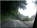
Bilsington - 2008
Bilsington, Ruckinge Road, B2067, Horn's Wood, 'The Beehive'.
Image: © Helmut Zozmann
Taken: 10 Jul 2008
0.20 miles
10
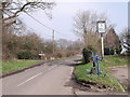
The B2067 at Ruckinge, Kent
The pub sign is for the Blue Anchor. This might seem an odd title for a pub so far from the sea, but in former times, before the draining of the marshes, the sea would have lapped the shores just below the village.
Image: © nick macneill
Taken: 2 Mar 2011
0.25 miles