IMAGES TAKEN NEAR TO
Lancaster Close, ASHFORD, TN26 2JG
Introduction
This page details the photographs taken nearby to Lancaster Close, TN26 2JG by members of the Geograph project.
The Geograph project started in 2005 with the aim of publishing, organising and preserving representative images for every square kilometre of Great Britain, Ireland and the Isle of Man.

There are currently over 7.5m images from over14,400 individuals and you can help contribute to the project by visiting https://www.geograph.org.uk
Image Map
Images are licensed for reuse under creativecommons.org/licenses/by-sa/2.0
Notes
- Clicking on the map will re-center to the selected point.
- The higher the marker number, the further away the image location is from the centre of the postcode.
Image Listing (163 Images Found)
Images are licensed for reuse under creativecommons.org/licenses/by-sa/2.0
Image
Details
Distance
2
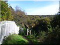
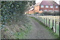
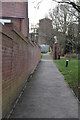
Footpath by Ham Street station
Ham Street station was opened on 13th February 1851, although the adjacent village is now shown on Ordnance Survey maps and road signs as Hamstreet. Like many former South Eastern Railway stations, the platforms are staggered and are linked by a central foot crossing - see http://www.geograph.org.uk/photo/3212695 This arrangement was constructed where a footbridge was not provided and allowed passengers to cross behind trains if two were at the station simultaneously. This footpath leads away from the foot crossing and links with the Greensand Way and Saxon Shore Way as they pass through Ham Street Woods National Nature Reserve. The latter can be seen ahead.
Image: © Marathon
Taken: 5 Nov 2012
0.08 miles
4
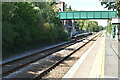
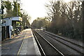
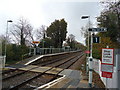
Ham Street station.
Ham Street (formerly Ham Street & Orlestone) is on the Ashford - Hastings line. Both line and station were opened by the South Eastern Railway on 13th February 1851. Although the village they serve is now spelt 'Hamstreet', successive railway managements have continued to use the older spelling of 'Ham Street'.
Image: © David Kemp
Taken: 23 Aug 2008
0.09 miles
5
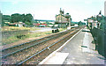
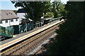
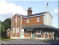
Hamstreet & Orlestone Railway Station: 1969
In 1969, I used to travel from Ashford to Hamstreet by train on certain Sunday mornings to meet my father in his car. I possess two single tickets for this journey, one is priced at 1/8 (8 p) and the other at 2/0 (10 p) - so the fare obviously went up at some stage. In 1969, the line was under threat of closure and the station was run down and in need of a lick of paint. As can be seen, it still had the SER diamond shaped lights.
Image: © John Baker
Taken: Unknown
0.09 miles