IMAGES TAKEN NEAR TO
The Street, ASHFORD, TN26 2BQ
Introduction
This page details the photographs taken nearby to The Street, TN26 2BQ by members of the Geograph project.
The Geograph project started in 2005 with the aim of publishing, organising and preserving representative images for every square kilometre of Great Britain, Ireland and the Isle of Man.

There are currently over 7.5m images from over14,400 individuals and you can help contribute to the project by visiting https://www.geograph.org.uk
Image Map (Loading...)


Getting Data...Please wait
Leaflet Map data © OpenStreetMap
Images are licensed for reuse under creativecommons.org/licenses/by-sa/2.0
Notes
- Clicking on the map will re-center to the selected point.
- The higher the marker number, the further away the image location is from the centre of the postcode.
Image Listing (257 Images Found)
Images are licensed for reuse under creativecommons.org/licenses/by-sa/2.0
Image
Details
Distance
2
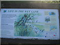
Life in the Wet Lane Information Board
Information Board beside the Romney Marsh Canal.
Seen near the Romney Marsh Canal Path gate near the B2080 Rhee Wall road bridge.
Image: © David Anstiss
Taken: 12 Sep 2010
0.02 miles
3

Swans, caravans and sheep under a tree, Appledore, 2014
The shed and caravan yard have since been built on.
Image: © Robin Webster
Taken: 29 May 2014
0.02 miles
4
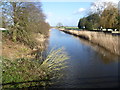
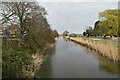
The Royal Military Canal at Appledore
The Royal Military Canal was built between 1804 and 1809 as a response to the threat of a Napoleonic invasion. At its peak there were 1,500 men working on the canal. The canal was dug entirely by hand, using picks and shovels and the soil was carried away in wheelbarrows. It runs for 28 miles between Seabrook near Folkestone and Cliff End near Hastings, and follows the old cliff line bordering Romney Marsh. Although it was never called into action, the canal was fortified with concrete pillboxes during the early stages of the Second World War, when a German invasion was looking likely. Its other original purpose was to act as a major drainage system for the winter, and a reservoir for the summer and so greatly improve conditions on Romney Marsh. It still does this today.
This is the view at Appledore. The Royal Military Canal Path follows the left hand bank here. The road on the right hand side is called Rhee Wall.
Image: © Marathon
Taken: 2 Feb 2014
0.02 miles
5
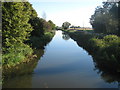
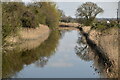
Romney Marsh Canal near Appledore
As seen from the Rhee Wall Road Bridge. The B2080 Rhee Wall is seen on the right.
Image: © David Anstiss
Taken: 12 Sep 2010
0.03 miles
8
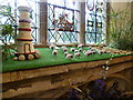
Flower festival at Appledore
The church of St Peter and St Paul at Appledore was largely reconstructed after a French raid in 1380. As usual the annual flower festival was being held over the August Bank Holiday weekend. The sheep are made from teasels. For the base of this display see http://www.geograph.org.uk/photo/4146563
Image: © Marathon
Taken: 25 Aug 2014
0.03 miles
9
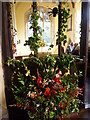
Flower festival at St Peter and St Paul Church, Appledore
The church of St Peter and St Paul at Appledore was largely reconstructed after a French raid in 1380. A flower festival was being held over the August Bank Holiday weekend entitled 'Crowning glory'.
Image: © Marathon
Taken: 27 Aug 2012
0.03 miles
10

St Peter and Paul Church, Appledore
Image: © Oast House Archive
Taken: 21 Jul 2013
0.03 miles