IMAGES TAKEN NEAR TO
Church Lane, ASHFORD, TN26 1LS
Introduction
This page details the photographs taken nearby to Church Lane, TN26 1LS by members of the Geograph project.
The Geograph project started in 2005 with the aim of publishing, organising and preserving representative images for every square kilometre of Great Britain, Ireland and the Isle of Man.

There are currently over 7.5m images from over14,400 individuals and you can help contribute to the project by visiting https://www.geograph.org.uk
Image Map
Images are licensed for reuse under creativecommons.org/licenses/by-sa/2.0
Notes
- Clicking on the map will re-center to the selected point.
- The higher the marker number, the further away the image location is from the centre of the postcode.
Image Listing (93 Images Found)
Images are licensed for reuse under creativecommons.org/licenses/by-sa/2.0
Image
Details
Distance
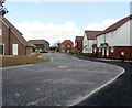
7
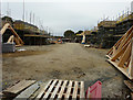
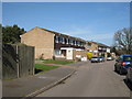
Houses under construction
The houses are being built on Image and this view is from a similar location.
Planning permission has been granted by Ashford Borough Council under application number 15/01496/AS for “residential development comprising 19 dwellings including 15 x 2 storey dwellings and 4 x 1 bedroom flats with associated infrastructure and services including garaging/provision for parking, open space, landscaping and a sustainable urban drainage system”.
The development has been called Berberis Place.
Image: © John Baker
Taken: 14 Oct 2018
0.08 miles
8
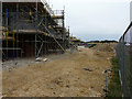
Houses under construction
The houses are being built on Image and this view is from a similar location.
Planning permission has been granted by Ashford Borough Council under application number 15/01496/AS for “residential development comprising 19 dwellings including 15 x 2 storey dwellings and 4 x 1 bedroom flats with associated infrastructure and services including garaging/provision for parking, open space, landscaping and a sustainable urban drainage system”.
The development has been called Berberis Place.
Image: © John Baker
Taken: 14 Oct 2018
0.09 miles
9
Berberis Place from a footpath
Planning permission was granted by Ashford Borough Council under application number 15/01496/AS for “residential development comprising 19 dwellings including 15 x 2 storey dwellings and 4 x 1 bedroom flats with associated infrastructure and services including garaging/provision for parking, open space, landscaping and a sustainable urban drainage system”.
Image: © John Baker
Taken: 14 Apr 2019
0.09 miles
10
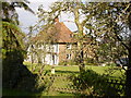
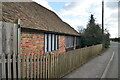
Woodgate House
White fronted Woodgate House from The Street, near Shadoxhurst Church.
Image: © D-G-Seamon
Taken: 10 Apr 2007
0.09 miles