IMAGES TAKEN NEAR TO
Woodchurch Road, ASHFORD, TN26 1LQ
Introduction
This page details the photographs taken nearby to Woodchurch Road, TN26 1LQ by members of the Geograph project.
The Geograph project started in 2005 with the aim of publishing, organising and preserving representative images for every square kilometre of Great Britain, Ireland and the Isle of Man.

There are currently over 7.5m images from over14,400 individuals and you can help contribute to the project by visiting https://www.geograph.org.uk
Image Map
Images are licensed for reuse under creativecommons.org/licenses/by-sa/2.0
Notes
- Clicking on the map will re-center to the selected point.
- The higher the marker number, the further away the image location is from the centre of the postcode.
Image Listing (67 Images Found)
Images are licensed for reuse under creativecommons.org/licenses/by-sa/2.0
Image
Details
Distance
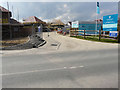
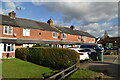
1
Entrance into a building site, Woodchurch Road
Planning permission has been granted by Ashford Borough Council under application number 15/01496/AS for “residential development comprising 19 dwellings including 15 x 2 storey dwellings and 4 x 1 bedroom flats with associated infrastructure and services including garaging/provision for parking, open space, landscaping and a sustainable urban drainage system”.
The development has been called Berberis Place.
Image: © John Baker
Taken: 14 Oct 2018
0.03 miles
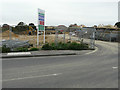
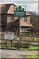
2
Berberis Place, Woodchurch Road
Before it was only the entrance to a Image but now a noticeboard has been erected to show the name of the development.
Image: © John Baker
Taken: 14 Apr 2019
0.04 miles
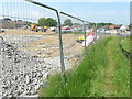
3
Building site, Woodchurch Road
This is where Image once stood. Planning permission was granted by Ashford Borough Council under application number 15/00373/AS for the “demolition of existing dwelling and erection of four new dwellings and four double garages with access and fencing to road frontage”.
Image: © John Baker
Taken: 9 Jul 2017
0.04 miles
4
Building site, Woodchurch Road
Planning permission was granted by Ashford Borough Council under application number 15/01496/AS for “residential development comprising 19 dwellings including 15 x 2 storey dwellings and 4 x 1 bedroom flats with associated infrastructure and services including garaging/provision for parking, open space, landscaping and a sustainable urban drainage system”.
This image shows the rerouted footpath from Woodchurch Road.
Image: © John Baker
Taken: 27 May 2018
0.04 miles
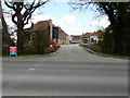
5
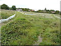
Land behind the King?s Head, Woodchurch Road
Planning permission has been granted by Ashford Borough Council under application number 15/01496/AS for “residential development comprising 19 dwellings including 15 x 2 storey dwellings and 4 x 1 bedroom flats with associated infrastructure and services including garaging/provision for parking, open space, landscaping and a sustainable urban drainage system”.
Two footpaths converge here and their routes, through the grass, have been marked out by the lengths of polythene affixed to small, wooden posts. The King’s Head is out of sight, as it is hidden by the two, large trees on the left.
Image: © John Baker
Taken: 3 Sep 2017
0.05 miles
7
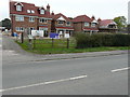
Houses under construction, Woodchurch Road
Planning permission was granted by Ashford Borough Council under application number 15/00373/AS for the “demolition of existing dwelling and erection of four new dwellings and four double garages with access and fencing to road frontage”.
The site used to be occupied by Image
Image: © John Baker
Taken: 14 Oct 2018
0.05 miles
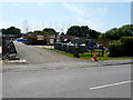
8
Wymondham, Woodchurch Road
Planning permission was granted by Ashford Borough Council under application number 15/00373/AS for the “demolition of existing dwelling and erection of four new dwellings and four double garages with access and fencing to road frontage”.
By July 2017, the site of the house had become a Image
Image: © John Baker
Taken: 13 Mar 2016
0.05 miles
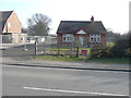
10
Chequers Green, Woodchurch Road
In October 2018, it was the Image Since then the site has acquired the name Chequers Green.
Image: © John Baker
Taken: 14 Apr 2019
0.06 miles