IMAGES TAKEN NEAR TO
Housemartin Road, TN25 7NA
Introduction
This page details the photographs taken nearby to Housemartin Road, TN25 7NA by members of the Geograph project.
The Geograph project started in 2005 with the aim of publishing, organising and preserving representative images for every square kilometre of Great Britain, Ireland and the Isle of Man.

There are currently over 7.5m images from over14,400 individuals and you can help contribute to the project by visiting https://www.geograph.org.uk
Image Map (Loading...)


Getting Data...Please wait
Leaflet Map data © OpenStreetMap
Images are licensed for reuse under creativecommons.org/licenses/by-sa/2.0
Notes
- Clicking on the map will re-center to the selected point.
- The higher the marker number, the further away the image location is from the centre of the postcode.
Image Listing (79 Images Found)
Images are licensed for reuse under creativecommons.org/licenses/by-sa/2.0
Image
Details
Distance
1
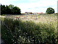
View of Finberry housing estate
From a track, which used to serve Bilham Farm. Finberry housing estate is a 168 hectare development site which will eventually contain 1180 homes making it the largest single development in Ashford since 2002 https://en.wikipedia.org/wiki/Finberry
Image: © John Baker
Taken: 12 Jul 2020
0.01 miles
2
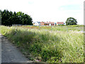
View of Finberry housing estate
From a track, which used to serve Bilham Farm. Finberry is a 168 hectare development site which will eventually contain 1180 homes making it the largest single development in Ashford since 2002 https://en.wikipedia.org/wiki/Finberry
This was a similar Image taken in July 2020.
Image: © John Baker
Taken: 11 Jul 2021
0.01 miles
3
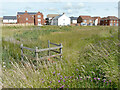
Expansion of the Finberry housing estate
Finberry is a 168 hectare development site which will eventually contain 1180 homes making it the largest single development in Ashford since 2002 https://en.wikipedia.org/wiki/Finberry
A similar view of the Image was taken in July 2020.
Image: © John Baker
Taken: 11 Jul 2021
0.02 miles
4
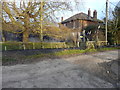
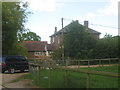
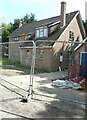
Bilham Farmhouse
This was Image before the windows were boarded over.
Image: © John Baker
Taken: 9 Jan 2019
0.03 miles
5
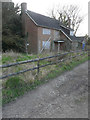
Bilham Farmhouse
Within Bilham Farm on an access road from Cheeseman's Green Lane.
Image: © David Anstiss
Taken: 30 May 2010
0.04 miles
6
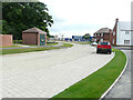
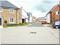
Swift Avenue
Swift Avenue is a road on the Finberry housing estate, which is a 168 hectare development site which will eventually contain 1180 homes making it the largest single development in Ashford since 2002 https://en.wikipedia.org/wiki/Finberry
This view of Image shows a red car, while this view shows it and the temporary end of the road.
Image: © John Baker
Taken: 29 May 2022
0.04 miles
8
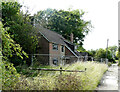
Upper Bilham Farmhouse
Image, which had boarded up windows, is now undergoing renovation, as new windows have been installed.
Image: © John Baker
Taken: 11 Jul 2021
0.05 miles
9
Upper Bilham Farmhouse
The house is undergoing renovation, as new windows have been installed.
Image: © John Baker
Taken: 11 Jul 2021
0.05 miles
10
Kestrel Drive
This was Image in January 2022; at the far end of the road, it bends left and continues as Image
Kestrel Drive is a road on the Finberry housing estate, which is a 168 hectare development site which will eventually contain 1180 homes making it the largest single development in Ashford since 2002 https://en.wikipedia.org/wiki/Finberry
Image: © John Baker
Taken: 29 May 2022
0.05 miles