IMAGES TAKEN NEAR TO
Avocet Way, ASHFORD, TN25 7GS
Introduction
This page details the photographs taken nearby to Avocet Way, TN25 7GS by members of the Geograph project.
The Geograph project started in 2005 with the aim of publishing, organising and preserving representative images for every square kilometre of Great Britain, Ireland and the Isle of Man.

There are currently over 7.5m images from over14,400 individuals and you can help contribute to the project by visiting https://www.geograph.org.uk
Image Map
Images are licensed for reuse under creativecommons.org/licenses/by-sa/2.0
Notes
- Clicking on the map will re-center to the selected point.
- The higher the marker number, the further away the image location is from the centre of the postcode.
Image Listing (84 Images Found)
Images are licensed for reuse under creativecommons.org/licenses/by-sa/2.0
Image
Details
Distance
1
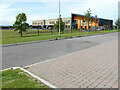
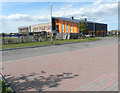
Finberry Primary School
Photographed from a parking bay, opposite the school, this was Image, when an extension was being added to the building. The school is on the Finberry housing estate, which is a 168 hectare development site which will eventually contain 1180 homes making it the largest single development in Ashford since 2002 https://en.wikipedia.org/wiki/Finberry
Image: © John Baker
Taken: 11 Jul 2021
0.02 miles
2
Finberry Primary School
This was Image, when an extension was being added to the building.
The school is on the Finberry housing estate, which is a 168 hectare development site which will eventually contain 1180 homes making it the largest single development in Ashford since 2002 https://en.wikipedia.org/wiki/Finberry
Image: © John Baker
Taken: 11 Jul 2021
0.02 miles
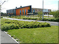
3
Finberry Primary School
An extension is being added to the school which will include 8 classrooms, associated stores and toilets, a learning resource centre, nursery facilities with access lobby and internal alterations to some existing spaces https://www.banyards.co.uk/projects/finberry-primary-school/
Opposite the school, parking bays have been created and there is a car parked in one of them.
Image: © John Baker
Taken: 12 Jul 2020
0.02 miles
4
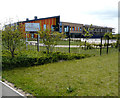
Finberry Primary School
An extension is being added to the school which will include 8 classrooms, associated stores and toilets, a learning resource centre, nursery facilities with access lobby and internal alterations to some existing spaces https://www.banyards.co.uk/projects/finberry-primary-school/
This was Image from the south.
Image: © John Baker
Taken: 12 Jul 2020
0.03 miles
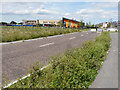
5
Finberry Primary School
An extension is being added to the school which will include 8 classrooms, associated stores and toilets, a learning resource centre, nursery facilities with access lobby and internal alterations to some existing spaces https://www.banyards.co.uk/projects/finberry-primary-school/
Parking bays have been installed opposite the school and this view of Image shows their location.
Image: © John Baker
Taken: 12 Jul 2020
0.03 miles
6
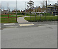
Children?s playground, Finberry housing estate
It was a Image and is situated opposite Finberry Primary School.
Image: © John Baker
Taken: 14 Oct 2018
0.04 miles
7
Robin Road
Robin Road is a road on the Finberry housing estate, which is a 168 hectare development site which will eventually contain 1180 homes making it the largest single development in Ashford since 2002 https://en.wikipedia.org/wiki/Finberry
The land beyond the group of people, who are on a New Year’s Day walk, is destined for development.
Image: © John Baker
Taken: 1 Jan 2022
0.05 miles
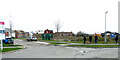
8
Avocet Way, Finberry housing estate
The board for Golding Homes is located on the corner of Image
Image: © John Baker
Taken: 14 Oct 2018
0.05 miles
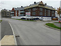
9

Avocet Way, Finberry housing estate
This view of Image shows when the ground floors of the houses, on the corner of Image, were hidden by hoarding. Judging by the wire fence along the verge, it appears that there is still some work to be carried out to make them habitable.
Image: © John Baker
Taken: 9 Jan 2019
0.06 miles
10
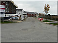
Robin Road
A road on the Finberry housing estate, where houses will probably be built along the right hand side.
This is how Image looked in October 2017.
Image: © John Baker
Taken: 14 Oct 2018
0.07 miles