IMAGES TAKEN NEAR TO
Pipin Crescent, ASHFORD, TN25 7GL
Introduction
This page details the photographs taken nearby to Pipin Crescent, TN25 7GL by members of the Geograph project.
The Geograph project started in 2005 with the aim of publishing, organising and preserving representative images for every square kilometre of Great Britain, Ireland and the Isle of Man.

There are currently over 7.5m images from over14,400 individuals and you can help contribute to the project by visiting https://www.geograph.org.uk
Image Map
Images are licensed for reuse under creativecommons.org/licenses/by-sa/2.0
Notes
- Clicking on the map will re-center to the selected point.
- The higher the marker number, the further away the image location is from the centre of the postcode.
Image Listing (92 Images Found)
Images are licensed for reuse under creativecommons.org/licenses/by-sa/2.0
Image
Details
Distance
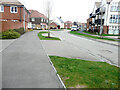
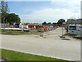
1
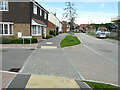
Pipin Crescent
Here viewed from its junction with Harriet Drive, which is a semi-circular road on the Finberry housing estate,: a 168 hectare development site which will eventually contain 1180 homes making it the largest single development in Ashford since 2002 https://en.wikipedia.org/wiki/Finberry
This was a similar view of Image in November 2019, before any development had started on the opposite side of the road.
Image: © John Baker
Taken: 11 Jul 2021
0.01 miles
2
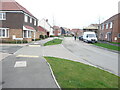
Pipin Crescent
Pipin Crescent is a road on the Finberry housing estate, which is a 168 hectare development site which will eventually contain 1180 homes making it the largest single development in Ashford since 2002 https://en.wikipedia.org/wiki/Finberry
This was a similar view of Image taken in July 2021, while this image was taken on New Year’s Day.
Image: © John Baker
Taken: 1 Jan 2022
0.01 miles
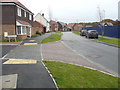
3
Pipin Crescent
A road on the Finberry housing estate, where houses will probably be built along the right hand side.
The white-painted house is also visible in this view of Image
Image: © John Baker
Taken: 14 Oct 2018
0.01 miles
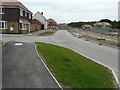
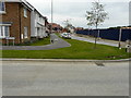
4
Pipin Crescent
Pipin Crescent is a road on the Finberry housing estate; a 168 hectare development site which will eventually contain 1180 homes making it the largest single development in Ashford since 2002 https://en.wikipedia.org/wiki/Finberry
This view shows the houses, which are being constructed on the opposite side of the road.
Image: © John Baker
Taken: 11 Jul 2021
0.01 miles
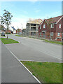
5
Pipin Crescent
Pipin Crescent is a road on the Finberry housing estate, which is a 168 hectare development site which will eventually contain 1180 homes making it the largest single development in Ashford since 2002 https://en.wikipedia.org/wiki/Finberry
This was a similar view of Image taken in July 2021, while this image was taken on New Year’s Day.
Image: © John Baker
Taken: 1 Jan 2022
0.01 miles
6
Pipin Crescent
A road on the Finberry housing estate, where houses will probably be built along the right hand side.
Image: © John Baker
Taken: 14 Oct 2018
0.01 miles
7
Pipin Crescent
Here viewed from its junction with Harriet Drive, which is a semi-circular road on the Finberry housing estate. Finberry is a 168 hectare development site which will eventually contain 1180 homes making it the largest single development in Ashford since 2002 https://en.wikipedia.org/wiki/Finberry
The house, beyond the cream-painted house, is the same house, as in this view of Image It also stands on the (other) corner of Harriet Drive.
Image: © John Baker
Taken: 24 Nov 2019
0.02 miles
8
Pipin Crescent
Pipin Crescent is a road on the Finberry housing estate,; a 168 hectare development site which will eventually contain 1180 homes making it the largest single development in Ashford since 2002 https://en.wikipedia.org/wiki/Finberry
This was Image before any development had started on the opposite side of the road.
Image: © John Baker
Taken: 11 Jul 2021
0.03 miles
9
Pipin Crescent
Pipin Crescent is a road on the Finberry housing estate,; a 168 hectare development site which will eventually contain 1180 homes making it the largest single development in Ashford since 2002 https://en.wikipedia.org/wiki/Finberry
A similar view to that of Image, but one which provides a better outlook of the road, which was subsequently named Kestrel Drive.
Image: © John Baker
Taken: 11 Jul 2021
0.03 miles
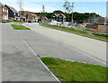
10

Kestrel Drive
A couple of people were walking in the road on New Year’s Day.
Kestrel Drive is a road on the Finberry housing estate, which is a 168 hectare development site which will eventually contain 1180 homes making it the largest single development in Ashford since 2002 https://en.wikipedia.org/wiki/Finberry
Image: © John Baker
Taken: 1 Jan 2022
0.03 miles